- Austin leaders consider expanding wildfire protection plan
- Large hail, strong winds and tornado threat possible into Thursday evening
- Large hail, tornado threat possible Thursday evening
- Jaccob Slavin scores in OT as the Hurricanes beat the Capitals in Game 1 of their 2nd-round series
- 5 On Your Side: What happened to cars flooded during Hurricane Helene?
Tropical Storm Ida forms, could hit the US at hurricane strength

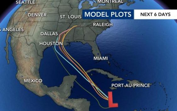
Tropical Storm Ida formed in the Caribbean on Thursday night, according to the National Hurricane Center. The storm is expected to be near major hurricane strength when it makes landfall near Louisiana or Mississippi late Sunday or Monday.
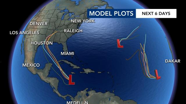
According to WRAL meteorologist Elizabeth Gardner, model plots show the system could affect the central coastline of the Gulf Coast late this weekend or early next week. The Storm was previously Tropical Depression Nine.
“It’s likely to be a hurricane by the time it makes landfall along the Gulf Coast early next week,” said WRAL meteorologist Kat Campbell on Thursday afternoon.
Before reaching the U.S., the system is forecast to track northwest between the Yucatan Peninsula and Cuba over the next 48 hours, according to WRAL meteorologist Zach Maloch.
Tropical storm warnings were issued for the Cayman Islands and portions of western Cuba, according to the National Hurricane Center.
It will then continue heading northwest and will most likely strengthen in the warm gulf waters, where minimal wind shear could help it develop.
“Models are consistent and grouped rather tightly together, which has this system making landfall around the Louisiana border sometime early Monday morning,” Maloch said. “That timing can change. Model intensity is rather sporadic.”
Two other systems are unlikely to affect the U.S. as they curve around an large area of high pressure centered in the far eastern Atlantic.
The peak of the Atlantic hurricane season is Sept. 10. Historically, mid-August through October is the most active period of the Atlantic season.
