- South and Midwest face potentially catastrophic rains and floods while reeling from tornadoes
- Deadly 2024 hurricanes prompt WMO to retire three names
- Body recovered in North Carolina identified as East TN man who has been missing ever since Hurricane Helene
- Report: Coastal flooding could threaten 1.4 million homes by midcentury
- Caught on camera | Tornado touches down in Missouri
Ida rapidly intensifies into a hurricane, expected to make landfall in Louisiana as a Category 4
Hurricane Ida is expected to make landfall along Louisiana’s Gulf Coast Sunday, likely as a Category 4 major hurricane.
CHARLOTTE, N.C. — The historic peak of hurricane season is September 10, but it is late August and September that some of the more notable storms have formed and even impacted the Carolinas.
Newly formed Hurricane Ida is expected to impact the northern Gulf coast this weekend. It’s too early to tell if the Carolinas will see notable impacts. Elsewhere, we have three areas to watch.
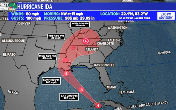
Hurricane Ida
Location: 90 miles southwest of Havana, Cuba
Potential Impacts: Western Cuba, United States northern Gulf coast
Ida strengthened quickly to a Category 1 hurricane just after 1 p.m. Friday. Shortly after, the storm made landfall on the Isle of Youth, the second-largest Cuban island.
The storm is expected to rapidly intensity to a Category 4 major hurricane over the weekend. Storm surge and hurricane warnings have been issued for the northern Gulf coast.
Ida will pass near and over western Cuba tonight. Due to minimal time over land, the terrain will not be enough to weaken Ida substantially. This weekend, the storm will emerge into the southeastern and central Gulf of Mexico. Then, it is forecast to approach the U.S. northern Gulf Coast on Sunday.
The latest track from the National Hurricane Center suggests a Category 4 major hurricane will make landfall along the Louisiana coast by Sunday afternoon. The intensity forecast is still subject to change due to the potential for rapid intensification. This is defined as a wind increase of 35 mph within a 24-hour period.
Historically, storm surge is the largest threat to life and property within a tropical cyclone. The water level rise due to Ida is expected to be the worst from Morgan City, LA to the mouth of the Mississippi River where the water levels could peak between 10 to 15 feet.
A Storm Surge Warning is in effect east of Rockefeller Wildlife Refuge Louisiana to the Mississippi/Alabama border, Vermilion Bay, Lake Borgne, Lake Pontchartrain, and Lake Maurepas.
A Storm Surge Watch is in effect for Sabine Pass to Rockefeller Wildlife Refuge, Louisiana, and Mobile Bay.
A Hurricane Warning is in effect for the Cuban provinces of Pinar del Rio and Artemisa, and the Isle of Youth, Intracoastal City, Louisiana to the Mouth of the Pearl River, Lake Pontchartrain, Lake Maurepas, and Metropolitan New Orleans.
A Hurricane Watch is in effect for Cameron, Louisiana to the west of Intracoastal City, Louisiana, the mouth of the Pearl River to the Mississippi/Alabama border.
A Tropical Storm Warning is in effect for the Cuban provinces of Matanzas, Mayabeque, and Havana, Cameron, Louisiana to the west of Intracoastal City, Louisiana, the mouth of the Pearl River to the Mississippi/Alabama border.
A Tropical Storm Watch is in effect for the Mississippi/Alabama border to the Alabama/Florida border.
Wave Number 1: Invest 97-L
Location: 600 miles east of Bermuda (central Atlantic)
Development Chance: 60% within the next five days
Potential Impacts: Mid-Atlantic Ocean
Development potential has lowered slightly for Invest 97-L over the past 24 hours. Conditions are marginally favorable for development late this week and this weekend, so a tropical depression could form as it drifts slowly eastward.
This system is no concern to the United States.
Wave Number 2: Invest 98-L
Location: South-central Atlantic
Development Chance: 80% within the next 2 – 5 days
Potential Impacts: Atlantic Ocean
An area of disorganized showers and thunderstorms continues to churn in the eastern Atlantic Ocean. Moderate development is possible within the next few days, however, unfavorable conditions are expected this weekend.
This disturbance has the best chance to become our next named storm.
Wave Number 3
Development Chance: 20% within the next five days
This is a new area to monitor in the Atlantic Basin. A tropical wave is expected to emerge off the African coast by mid-next week. Conditions will be marginally conducive for development.
It’s much too early to know what could happen with this disturbance. Stay tuned for updates!