- Tuesday's wildfires scorched more than 500 acres in south Bexar County
- How big were this week's wildfires in Bexar County?
- Crews contain wildfire in southeast Williamson County
- Wildfire contained to 300 acres in northwest Matagorda County
- Bill would make it easier for homeowners to afford upgrades to protect from storm damage
Hurricane Ida storm surge flooding parts of Louisiana ahead of 150 mph winds

NEW ORLEANS — Hurricane Ida was rapidly intensifying early Sunday, becoming a dangerous Category 4 hurricane on track for a potentially devastating landfall on the Louisiana coast while emergency officials in the region grappled with opening shelters for displaced evacuees despite the risks of spreading the coronavirus.
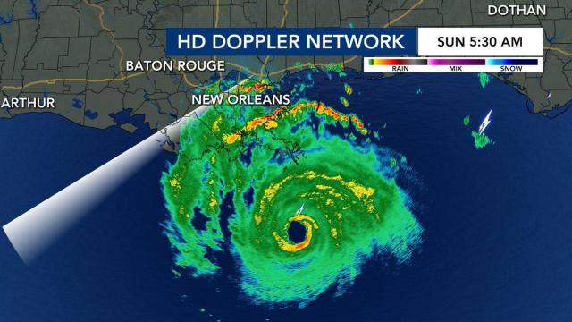
The 12 p.m. advisory from the National Hurricane Center showed Ida was 25 miles south-southwest of Grand Isle, Louisiana. WRAL meteorologist Aimee Wilmoth said Grand Isle was reportedly under water due to storm surge.
Ida quickly gained strength as it moved into the northern Gulf, with top winds of 150 mph at 7:30 a.m., a large increase from 115 mph a few hours previously. Hurricane Hunters flying through Ida found a surface wind of 168 mph.
“You have to have 157 mph to have a Category 5, so we could have a Category 5 on our hands,” said Wilmoth.
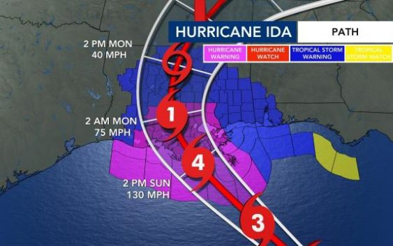
As of the 8 a.m. update, Hurricane Ida is still considered a Category 4, but it’s projected to make landfall at just under a Category 5, with maximum sustained winds at 155 mph – just two miles per hour less than a Category 5.
Parts of Louisiana are expected to get up to 20 inches of rainfall. Areas in Alabama and Mississippi are forecast for up to 7 inches of rain. Even the North Carolina mountains could get up to 3 inches of rain, which could impact communities already cleaning up from flood and mudslide damage created by Fred.
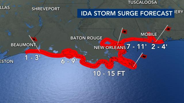
The storm surge is expected to reach up to 15 feet, with waves already choppy ahead of the storm, reaching up to 31 feet just offshore.
The storm was centered about 65 miles south of the mouth of the Mississippi River, and 80 miles south-southeast of costal Grand Isle, Louisiana. It was traveling northwest at 15 mph.
The system was expected to make landfall Sunday afternoon, set to arrive on the exact date Hurricane Katrina ravaged Louisiana and Mississippi 16 years earlier.
National Guard stages in Louisiana; residents prepare for power outages, sweltering heat
Comparisons to the Aug. 29, 2005, landfall of Katrina weighed heavily on residents bracing for Ida. A Category 3 storm, Katrina was blamed for 1,800 deaths as it demolished oceanfront homes in Mississippi and caused levee breaches and catastrophic flooding in New Orleans.
Around 5,000 National Guard troops were being staged in 14 Louisiana parishes for search and rescue efforts. And 10,000 linemen were on standby to respond to electrical outages.
In Saucier, Mississippi, Alex and Angela Bennett spent Saturday afternoon filling sand bags to place around their flood-prone home. Both survived Katrina, and didn’t expect Ida to cause nearly as much destruction where they live, based on forecasts.
“Katrina was terrible. This ain’t gonna be nothing,” Alex Bennett said. “I hate it for Louisiana, but I’m happy for us.”
Long lines formed at gas pumps Saturday as people rushed to escape. Trucks pulling saltwater fishing boats and campers streamed away from the coast on Interstate 65 in Alabama, while traffic jams clogged Interstate 10 heading out of New Orleans.
Ida intensified so swiftly that New Orleans officials said there was no time to organize a mandatory evacuation of its 390,000 residents. Mayor LaToya Cantrell urged residents to leave voluntarily. Those who stayed were warned to prepare for long power outages amid sweltering heat.
Officials also stressed that the levee and drainage systems protecting the city had been much improved since Katrina. But they cautioned flooding was still possible with up to 24 inches (61 centimeters) of rain forecast in some areas.
Ida posed a threat far beyond New Orleans. A hurricane warning was issued for nearly 200 miles (320 kilometers) of Louisiana’s coastline, from Intracoastal City south of Lafayette to the Mississippi state line. A tropical storm warning was extended to the Alabama-Florida line.
Meteorologist Jeff Masters, who flew hurricane missions for the government and founded Weather Underground, said Ida is forecast to move through “the just absolute worst place for a hurricane.”
The Interstate 10 corridor between New Orleans and Baton Rouge is a critical hub of the nation’s petrochemical industry, lined with oil refineries, natural gas terminals and chemical manufacturing plants. Entergy, Louisiana’s major electricity provider, operates two nuclear power plants along the Mississippi River.
A U.S. Energy Department map of oil and gas infrastructure shows scores of low-lying sites in the storm’s projected path that are listed as potentially vulnerable to flooding.
Hospitals nearly full already; shelters concerned about becoming flashpoints for new COVID infections
Ida threatened a region already reeling from a resurgence of COVID-19 infections, thanks to low vaccination rates and the highly contagious delta variant.
New Orleans hospitals planned to ride out the storm with their beds nearly full, as similarly stressed hospitals elsewhere had little room for evacuated patients. And shelters for those fleeing their homes carried an added risk of becoming flashpoints for new infections.
Gov. John Bel Edwards vowed Saturday that Louisiana’s “resilient and tough people” would weather the storm. He also noted shelters would operate with reduced capacities “to reflect the realities of COVID.”
Edwards said Louisiana officials were already working to find hotel rooms for many evacuees so that fewer had to stay in mass shelters. He noted that during last year’s hurricane season, Louisiana found rooms for 20,000 people.
“So, we know how to do this,” Edwards said. “I hope and pray we don’t have to do it anywhere near that extent.”
In coastal Gulfport, Mississippi, a Red Cross shelter posted signs displaying directions for evacuees along with warnings about COVID-19. With skies still sunny, only a handful of people had shown up Saturday evening.
Shelter manager Barbara Casterlin said workers were required to wear face masks. Evacuees were encouraged to do the same. Anyone who refuses will be sent to an isolated area, she said, and so will people who are sick.
“We’re not checking vaccinations,” Casterlin said, “but we are doing temperature checks two or three times a day.”
President Joe Biden approved emergency declarations for Louisiana and Mississippi ahead of Ida’s arrival.
___
Reeves reported from Gulfport, Mississippi. Associated Press writers Rebecca Santana, Stacey Plaisance and Janet McConnaughey in New Orleans; Emily Wagster Pettus in Jackson, Mississippi; Jeff Martin in Marietta, Georgia; Seth Borenstein in Kensington, Maryland; Frank Bajak in Boston; and Michael Biesecker in Washington.

