- South and Midwest face potentially catastrophic rains and floods while reeling from tornadoes
- Deadly 2024 hurricanes prompt WMO to retire three names
- Body recovered in North Carolina identified as East TN man who has been missing ever since Hurricane Helene
- Report: Coastal flooding could threaten 1.4 million homes by midcentury
- Caught on camera | Tornado touches down in Missouri
Day 4 of Ida to bring more heavy, flooding rains

CHARLOTTE, N.C. —
Excessive Rainfall:
Northeast Rainfall:
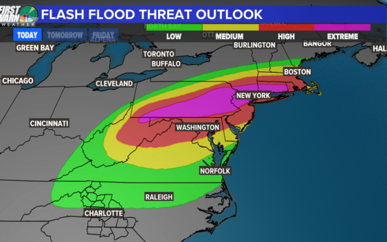
Flash flooding could be extensive and even historic for the Mid-Atlantic to the Northeast United States. The most intense rain looks to be from Eastern Pennsylvania through New York. A fancy weather term, QPF (Quantitative Precipitation forecast) is pointing towards a range of 3-8″ of rain. Most will be in the 2-5″ range but some areas will see consistent heavy rain for several hours and this is where the danger lies.
Flash Flood Watches are painted across Ida’s path and concern grows by Wednesday afternoon into the evening. A rare extensive excessive rainfall tag is trapped from the area that could have devastating flooding from this event.
Eastern Pennsylvania, Northern New Jersey, Southern New York and Southern Connecticut got a lot of rain from Henri and have not completely dried out.
This will be a major story.
The North Carolina Mountains Rainfall:
The last of the rain could still dump another 2-4″+ for northeast North Carolina and western Virginia. The Flash Flood Watch will last until Wednesday evening or midnight at the latest for Watauga, Ashe and Wilkes County.
Severe Potential:
Carolinas:
The severe potential will come in the last line of possible storms this afternoon. The worst of the weather looks to be north and east of our area, since that will be closest to the center of Ida where there is more shear, which leads to more tornadoes and stronger thunderstorms.
Tornado Threat:
The worst of the severe weather today will be under Ida as it moved northeast. There is a 10% bullseye in Maryland, Delaware and New Jersey. For example, we were under a 10% chance for tornadoes during Tropical Storm Fred in the Carolinas, and the Greenville-Spartanburg National Weather Service issued 37 tornado warnings.
There is still a better threat around Raleigh and even east of Charlotte in the WCNC viewing area has a slight chance for a rotating storm.
In summary, Ida’s last breath looks to be substantial with the threat of dangerous flash flooding, strong storms and tornadoes.
As the severe weather risk is strong for the mountains and western parts of the region, emergency crews are preparing now. The Charlotte Fire Department says their own Task Force 3 is deploying to a forward staging area in Conover to aid in responding to the potential impact Ida’s remains will bring. This includes a 23-member swift water team that will be on standby.
A Flash Flood Watch is in effect until Wednesday afternoon. Our biggest threat during this period is flash flooding in the mountains. The threat outlook is medium to high for western North Carolina, primarily over the mountains in Avery, Watauga, and Ashe counties, as well as the foothills in Caldwell and Burke counties. All have a medium risk of flash flooding as heavy rain bands overhead later today and tonight.
Up to two inches of rainfall is possible for the communities in and around the Charlotte metro and two to four inches of rainfall may impact the mountains. Locally higher amounts are possible where heavy rain bands develop. Rainfall of five inches or more in similar storms has resulted in flooding on roadways, landslides, and rockslides.
Meanwhile, much of the daylight will likely remain dry into the afternoon with only a slight chance for showers and storms. Be on alert with multiple ways to get notified if a tornado warning is issued. Right now, there is not a tornado watch in effect for the Charlotte area.
🌩️ If you like weather, join Brad Panovich and the WCNC Charlotte First Warn Weather Team on their YouTube channel, Weather IQ. 🎥