- Seven months after Hurricane Helene, Chimney Rock rebuilds with resilience
- Wildfire in New Jersey Pine Barrens expected to grow before it’s contained, officials say
- Storm damage forces recovery efforts in Lancaster, Chester counties
- Evacuation orders lifted as fast-moving New Jersey wildfire burns
- Heartbreak for NC resident as wildfire reduces lifetime home to ashes
Isolated tornadoes possible as storms and rain move into central NC

Remnants from Ida will bring rain and storms to central North Carolina beginning Wednesday afternoon.
WRAL meteorologist Elizabeth Gardner said scattered showers and storms could move in after lunchtime and may not clear until after midnight. Rain could be heavy at times, and storms could become severe with isolated tornadoes possible.
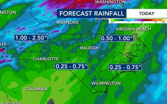
The threat for severe weather will be greatest close to the Virginia line, where Hertford and Northampton counties are under a tornado watch until 7 p.m. While central North Carolina will receive less than 1 inch of rain, Ida’s track means Pennsylvania and West Virginia could see excessive rainfall, as much as 5 to 7 inches of rain. Ida’s remnants will reach the New England coastline by the end of the week.
In the Triangle on Wednesday afternoon, wind gusts above 30 mph and tornadoes will be possible but isolated. Much of the state is under a Level 2 risk for severe weather, and the chance for storms will increase throughout the afternoon.
Download the WRAL Weather app to get severe weather alerts
“The main threat is going to be the threat for rain and thunderstorms,” said WRAL meteorologist Kat Campbell. “Isolated tornadoes and damaging wind gusts will be possible, especially during the afternoon and evening.”
Live cameras provide a look at conditions across the region
Track rain with the DualDoppler5000
Flooding is not expected to be an issue locally, as central North Carolina should see less than 1 inch of rain from Ida. The mountains saw between 2 and 3 inches of rain on Tuesday, much less than the devastating impacts caused by Fred last month.
Five water rescue teams, including two from Apex and Morrisville, deployed to western North Carolina on Tuesday in preparation of additional flooding.
Ida battered Louisiana on Sunday, ripping roofs off homes and threatening flooding. The storm then wreaked havoc in Mississippi. As of Tuesday morning, four deaths have been blamed on Ida.
Tropical Storm Larry forms
Tropical Storm Larry formed Wednesday morning off the coast of Africa but is not expected to impact land.
Tropical Depression Kate, also not a threat to land, will continue to move northward over open waters in the central Atlantic.
Meteorologists are watching a low pressure system over the southwestern Caribbean Sea that has a slight chance of developing over the next couple of days as it moves to the west-northwest. Heavy rain possible is across Central America and the Yucatan Peninsula.
The peak of the Atlantic hurricane season is Sept. 10. Historically, mid-August through October is the most active period of the Atlantic season.


