- Montgomery County residents unite to weather freezing temperatures and rebuild after tornado damage
- New charge filed against ex-security guard accused of using hidden cameras to take videos of girls at The Woodlands Mall, Hurricane Harbor
- Mecklenburg County residents can attend sessions this week to apply for Hurricane Helene disaster relief
- Steiner Ranch deploys goats for wildfire prevention efforts
- Goats graze greenbelt to reduce wildfire risk in Steiner Ranch
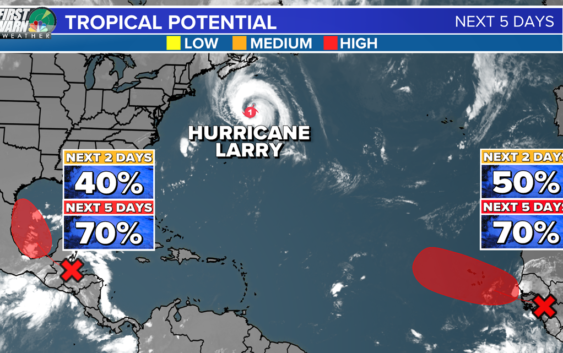
As Hurricane Larry parallels the U.S. east coast, two other areas have a high chance for development

Large and powerful Hurricane Larry is racing toward Newfoundland. Elsewhere, we have two areas of interest likely to develop.
CHARLOTTE, N.C. — On the historic peak of hurricane season, we have a relatively active Atlantic basin.
Mindy is no more as the system merged with a cold front yesterday. Hurricane Larry remains a Category 1 hurricane with maximum sustained winds of 85 mph. The storm is racing toward southeastern Newfoundland.
Larry is expected to bring hurricane-force winds, a dangerous storm surge, and heavy rainfall to the province tonight.
While Larry won’t have a direct landfall anywhere close to the United States, swells generated by the hurricane are impacting the east coast already. This has prompted a high rip current risk for the Carolina beaches, and rough surf can be expected too.
Near Honduras and the Yucatan Peninsula, we have a tropical wave showing new signs of life this morning. This disturbance is forecast to move into the Bay of Campeche this weekend as it merges with a low-pressure system.
At this point, conditions are expected to be favorable for development. Quickly afterward, models have suggested the depression or storm will move onshore along the Mexico coast. Regardless of where the system goes, the system will bring heavy rain, mud, and landslides to portions of Central America this weekend.
That tropical moisture will bring heavy rain all up and down the United States Gulf coast next week. Right now, the National Hurricane Center is giving it a 70% chance of development over the next five days.
Lastly, a vigorous tropical wave is expected to emerge off the west coast of African by tonight. Environmental conditions will be ripe for formation, and a tropical depression or storm could develop as early as this weekend.
Long-range forecast models suggest a track staying out to sea, but we’ll monitor the system closely. Right now, the National Hurricane Center is giving it a 70% chance of development over the next five days.
RELATED: Peak hurricane season just days away