- Austin leaders consider expanding wildfire protection plan
- Large hail, strong winds and tornado threat possible into Thursday evening
- Large hail, tornado threat possible Thursday evening
- Jaccob Slavin scores in OT as the Hurricanes beat the Capitals in Game 1 of their 2nd-round series
- 5 On Your Side: What happened to cars flooded during Hurricane Helene?
Tropical Storm Nicholas forms, tracking four tropical waves

We’re deep into the most active month of hurricane season and the WCNC Charlotte weather team is tracking five systems.
CHARLOTTE, N.C. — We have a lot of active weather in the Atlantic Basin, so let’s get right to it. There are five areas of interest, but one that is coming nowhere close to the United States.
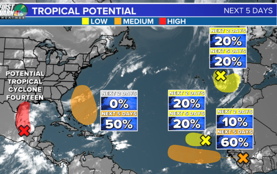
First, Invest 94-L (the area shaded in red) has a 90% chance of becoming our next depression or named storm, as early as today. The system is currently moving through the Bay of Campeche and shows better organization over the past 24 hours. Hurricane Hunters will be investigating it today.
Eventually, it moves into waters rich with moisture and warmth over the western and northwestern Gulf of Mexico. Its there where it could find additional develop as it approaches the southeastern Texas coastline.
Regardless of formation, the disturbance will continue to produce heavy rain across portions of southern Mexico today, which may lead to flash flooding and mudslides. Later today, heavy rainfall will overspread into coastal portions of Texas and Louisiana, potentially resulting in areas of flash, urban, and isolated river flooding. Rainfall totals could exceed 5-7 inches in spots.
The second area we’ll discuss is near the Bahamas right now. This is a weak tropical wave interacting with an upper-level trough that is producing disorganized showers and storms.
Gradual development is possible and the National Hurricane Center is giving it a 50% chance of development over the next five days.
Long-term forecast models indicate the system will stay away from the United States east coast due to a strong ridge of high pressure and approaching cold front. This is subject to change, so we’ll monitor closely.
Nevertheless, this kind of tropical activity in the western Atlantic could elevate our rip current risk again for the coastal Carolinas. It’ll depend on eventual track and strength.
Elsewhere, there are two additional tropical waves near Africa. One is bringing locally heavy rain to the Cabo Verde Islands and one is expected to emerge off the African coast this week.
The area shaded in yellow (20%) is unlikely to form into anything tropical at this point due to high wind shear. However, there is a possibility as it breaks down, its energy essentially merges into the area shaded in orange (60%).
Regardless of whether the two merge or the systems stay separate, models do indicate a slow westerly movement heading through this upcoming week and next. At that point, whatever energy comes from this tropical system could not only become a depression or named storm, but most likely a hurricane.
It is far too early to tell where it could go, but it bears watching closely.
The last area of low pressure, which I X’ed out on the graphic, is a few hundred miles east-northeast of the Azores. Whether it develops or not, it’s forecast to move inland over Portugal and will never be a threat to the Carolinas or the United States.
The next two names on the 2021 Atlantic hurricane list are Nicholas and Odette.