- Seven months after Hurricane Helene, Chimney Rock rebuilds with resilience
- Wildfire in New Jersey Pine Barrens expected to grow before it’s contained, officials say
- Storm damage forces recovery efforts in Lancaster, Chester counties
- Evacuation orders lifted as fast-moving New Jersey wildfire burns
- Heartbreak for NC resident as wildfire reduces lifetime home to ashes
Tropical Storm Nicholas strengthens slightly, nears Texas coast

Nicholas is expected to maintain Tropical Storm strength as it travels across the Texas coast.
CORPUS CHRISTI, Texas — 4 p.m. UPDATE:
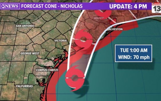
Nicholas has strengthened 5mph since 1pm and is now a 65 mph tropical storm; winds gusting up to 75 mph. Nicholas is moving NNE at 12 mph. It’s about 60-70 miles away from Matagorda Bay.
The 4PM NHC update takes Nicholas near Matagorda Bay at landfall this evening as a 70 mph tropical storm. Nicholas then slows and weakens over SE Texas and Louisiana through Thursday, where flooding rains will be the primary threat – 6-12″ possible there.
WIND: Nicholas will continue to bring tropical storm force conditions to parts of the Coastal Bend through Monday night. Winds will be northwesterly as the storm moves in to the Middle Texas Gulf Coast.
RAIN: With a track a little farther into the Gulf of Mexico, rain totals will be lower, with areas around Copano/San Antonio Bay still getting another 1-3″. Rain (like winds) will be moving in from the NW, wrapping around the west side of Nicholas. Rain chances drop after midnight in the Coastal Bend.
SURGE: Baffin Bay and Corpus Christi Bay will see a reduction in storm surge through Monday night with winds coming in from the N/NW. Some flooding on the bay side of barrier islands/canals will be possible overnight. 3-5 ft. surge near Matagorda Bay, where landfall is expected.
As of the 1 AM CDT update from the National Hurricane Center, Tropical Storm Nicholas has maintained its strength in the western Gulf of Mexico. Nicholas has winds sustained at 60 mph, with gusts of 70 mph.
Nicholas is expected to maintain its Tropical Storm status as it pushes up the Mexican coastline and near South Texas by Monday afternoon. The storm is expected to make landfall along the Texas coast sometime between Monday evening and early Tuesday morning. In the Coastal Bend, the worst of the impacts will be seen Monday evening. The latest forecast track has been moved slightly eastward, which would bring the worst of the conditions offshore and up towards Matagorda Bay.
Tropical Storm warnings have been issued for coastal portions of the Coastal Bend until Tuesday afternoon. That means tropical storm-force winds are expected. Those are wind speeds ranging from 39 mph to 73 mph. A Hurricane Watch has been issued from Port Aransas to Port O’Connor as a precaution as Nicholas strengthens.
A potentially life-threatening storm surge could also occur along the Texas coast. Corpus Christi is expected to see 2-4 feet of storm surge, as is most of coastal Texas from the Mouth of the Rio Grande all the way north to Galveston Bay and High Island
Wind gusts of 65+ mph will be seen near the center of the storm as it comes ashore late Monday into Tuesday. Much less winds are expected further west. The Corpus Christi area is still expected wind gust of tropical storm strength Monday evening.
Flooding is the main concern from this system. Rainfall totals will range vastly from western counties to coastal counties. Coastal areas are expected to see over a half-foot of rain, with a few isolated locations possibly picking up on near 10 inches.
Here is the latest thinking of overall impacts in the Coastal Bend:
RELATED: 2021 Hurricane Guide: Download Now
————————————————————
September is historically the most active time of the Atlantic hurricane season. This is when we see the most frequent long track storms come off of Africa. The Caribbean, Gulf of Mexico, and Atlantic Basin are all ‘open’ for tropical activity.
August and September are when the Atlantic Hurricane Season traditionally becomes more active. Warmer waters and a more favorable environment for tropical develop become more prevalent. Be weather aware and keep up with the forecast.
The KIII pre-season hurricane forecast was for 20 named storms, 10 hurricanes, and 4 major hurricanes. An above average season, partly because of a weak la nina.
Below is a list of the 2021 hurricane names. The tropical icon next to the name designates the name has been used and what the peak status of that storm was.