- South and Midwest face potentially catastrophic rains and floods while reeling from tornadoes
- Deadly 2024 hurricanes prompt WMO to retire three names
- Body recovered in North Carolina identified as East TN man who has been missing ever since Hurricane Helene
- Report: Coastal flooding could threaten 1.4 million homes by midcentury
- Caught on camera | Tornado touches down in Missouri
Hurricane Nicholas bearing down on the Texas coast

The storm was upgraded Monday night and is bringing strong wind, storm surge and heavy rain.
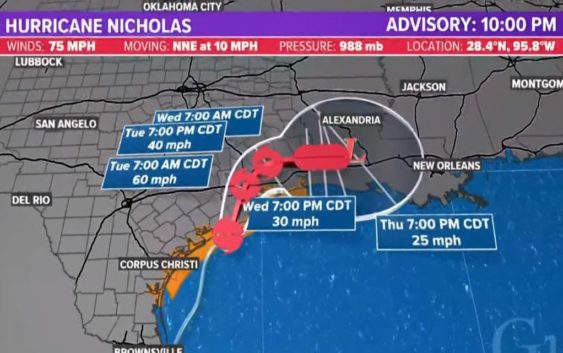
HOUSTON — Nicholas became a hurricane Monday night as it pushed toward the Texas coast. It’s expected to make landfall at some point early Tuesday morning somewhere near Freeport.
With the 10 p.m. update, Nicholas had maximum sustained winds of 75 mph and was moving to the north-northeast at 10 mph. It’s causing power outages on Galveston Island and along the coast.
The track takes Nicholas through Brazoria County and Galveston County. It slows it down as it nears the Texas-Louisiana border.
Chief Meteorologist David Paul and Addison Green were tracking the storm for KHOU 11 News at 10 p.m. You can watch their forecast here:
Conditions from Hurricane Nicholas
Reporter Zack Tawatari was reporting from Galveston, where the wind was picking up.
And in Palacios, Xavier Walton was in a spot seeing the worst of Nicholas, where wind was knocking down power lines.
And reporter Matt Dougherty was moving across the Houston area in our weather tracker, checking conditions.
Forecast cone and timing for Hurricane Nicholas
The latest forecast cone, which you can see below, shows the storm will come ashore early Tuesday. The Houston area could get wind gusts in excess of 40-50 mph. The center of the storm will pass right over downtown Houston Tuesday.
Expected rainfall totals for Hurricane Nicholas
These are the rainfall estimates as of 11:30 p.m. Monday.
Key messages from the National Hurricane Center – 10 p.m.
1. Heavy rainfall will impact portions of southeastern Texas, Louisiana, and southern Mississippi through the middle of the week. Significant rainfall amounts are expected, potentially resulting in areas of life-threatening flash and urban flooding, along the eastern Texas coast into southwestern Louisiana. Minor to isolated major river flooding is also possible in smaller river basins and urban areas.
2. There is the danger of life-threatening storm surge inundation along the coast of Texas from Port Aransas to Sabine Pass. Residents in these areas should follow any advice given by local officials.
3. Hurricane conditions are expected within the Hurricane Warning area and Tropical storm conditions are expected with the Tropical Storm Warning area along the Texas coast.