- Western NC wildfire risk will 'get worse, not better' Ag Commissioner says, pressing lawmakers for help
- Watering trees is a must to protect them from severe weather and drought
- At least 4 dead, hundreds rescued after deadly floods ravage South Texas
- Today on Texas Standard: Deadly floods swamp South Texas, shatter records
- North Carolina radio station was a critical lifeline after Hurricane Helene. Then it became the voice of recovery.
Hurricane Nicholas moving toward Texas landfall: Track the storm, spaghetti models

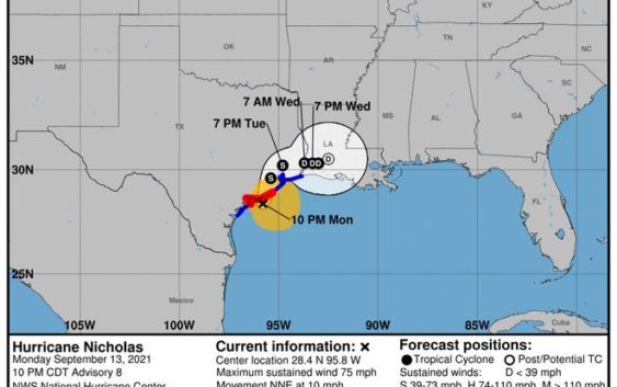
Hurricane Nicholas is bringing heavy rains, strong winds and storm surges to portions of the central and upper Texas coast. It’s forecast to make landfall along the central Texas coast late Monday evening or early Tuesday morning.
Hurricane Nicholas has maximum sustained winds of 75 mph, according to the 10 p.m. advisory from the National Hurricane Center.
The Hurricane Watch south of Port O’Connor is discontinued and the Tropical Storm Warning south of Port Aransas is discontinued. The Hurricane Watch from Port O’Connor north to Freeport has been upgraded to a Hurricane Warning.
The storm could bring rains of 6 to 12 inches, with isolated maximum amounts of 18 inches, across portions of the middle and upper Texas coastal areas through Wednesday. Interior southeast Texas and parts of Louisiana and Mississippi could see rainfall totals from 4 to 8 inches. The storm rainfall could cause considerable flash and urban flooding.
Hurricane-force-winds extend 25 miles and tropical-storm-force winds extend 115 miles from the center.
The storm is located 45 miles southwest of Freeport, and is moving north northeast at 10 mph. Weakening is anticipated as it moves onshore. The system is expected to begin a northeastern movement Tuesday.
Cone of uncertainty: See the latest graphic from the NHC
Satellite images: See latest satellite image from NOAA, for a clearer picture of the storm’s size
In Corpus Christi, officials have prepared by closing Beach Access Road 4, and Kingsville ISD canceled classes for Monday. Flooding is expected in the area.
Latest data on Hurricane Nicholas
Here is the latest data on Hurricane Nicholas pulled from the National Hurricane Center’s 1 p.m. advisory.
- Location: 45 miles southwest of Freeport
- Maximum sustained winds: 75 mph
- Movement: North at 10 mph
- Pressure: 988 MB (millibars)
- When next advisory will be released: 4 a.m. CT
More:Tropical Storm Nicholas: How much rain, flooding is expected for South Texas?
Watches, warnings and evacuations
A Storm Surge Warning is in effect for:
- Port Aransas Texas to Sabine Pass
- Galveston Bay, Aransas Bay, San Antonio Bay, and Matagorda Bay
A Hurricane Warning is in effect for:
- Port O’Connor to Freeport Texas
A Hurricane Warning is in effect for:
A Tropical Storm Warning is in effect for:
- North of Port Aransas to Sabine Pass
A Storm Surge Watch is in effect for:
- Sabine Pass to Rutherford Beach Louisiana
More:Watch live webcam as Tropical Storm Nicholas moves up the Gulf coast