- Report: Coastal flooding could threaten 1.4 million homes by midcentury
- Caught on camera | Tornado touches down in Missouri
- Carolina Hurricanes playoff tickets go on sale next week
- Storms kill 6 in the South and Midwest as forecasters warn of catastrophic rains, floods this week
- Weather Impact Alert: Cold front could trigger severe weather in Houston area this weekend | See timeline
Nicholas downgraded to tropical storm with winds at 70 mph early Tuesday

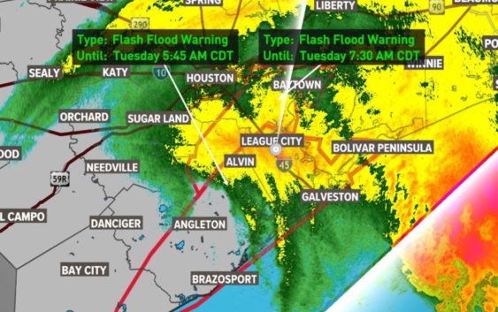
Gusty winds are reported across the Houston region, knocking out power to more than 300,000.
HOUSTON — Hurricane Nicholas made landfall along the Texas coast early Tuesday morning. The Category 1 storm came ashore near Sargent in eastern Matagorda County, according to the National Hurricane Center.
LIVE VIDEO NOW: KHOU 11 is on the air with extended team coverage / watch live above
With the 1 a.m. update, Nicholas had maximum sustained winds of 75 mph and was moving to the north-northeast at 10 mph. It quickly caused power outages on Galveston Island and other spots along the coast before moving insland.
In the 4 a.m. update, the NHC downgraded it back to a tropical storm with winds at 70 mph.
The track takes Nicholas through Brazoria County and Galveston County. It slows it down as it nears the Texas-Louisiana border.
The storm made a turn to the north-northeast just before 10 p.m. The turn was a bit unexpected and has kept the center just off the coast.
It’s also shifting the track further to the east. This may send most of the heavier rain and flooding potential further east than earlier anticipated.
It appears the upper-level winds out of the west may have given Nicholas this little bump to the east. Small shifts in track have large impacts on exactly which parts of the area will see the heaviest wind and rain.
Chief Meteorologist David Paul and Meteorologist Addison Green were tracking the storm for KHOU 11 News at 10 p.m. You can watch their forecast here:
Conditions from Hurricane Nicholas
Reporter Zack Tawatari was reporting from Galveston, where the wind was picking up.
And in Palacios, Xavier Walton was in a spot seeing the worst of Nicholas, where wind was knocking down power lines.
And reporter Matt Dougherty was moving across the Houston area in our weather tracker, checking conditions.
Forecast cone and timing for Hurricane Nicholas
The latest forecast cone, which you can see below, shows the storm will come ashore early Tuesday. The Houston area could get wind gusts in excess of 40-50 mph. The center of the storm will pass right over downtown Houston Tuesday.
Watches and warnings
Expected rainfall totals for Hurricane Nicholas
These are the rainfall estimates as of 11:30 p.m. Monday.
Key messages from the National Hurricane Center – 10 p.m.
1. Heavy rainfall will impact portions of southeastern Texas, Louisiana, and southern Mississippi through the middle of the week. Significant rainfall amounts are expected, potentially resulting in areas of life-threatening flash and urban flooding, along the eastern Texas coast into southwestern Louisiana. Minor to isolated major river flooding is also possible in smaller river basins and urban areas.
2. There is the danger of life-threatening storm surge inundation along the coast of Texas from Port Aransas to Sabine Pass. Residents in these areas should follow any advice given by local officials.
3. Hurricane conditions are expected within the Hurricane Warning area and Tropical storm conditions are expected with the Tropical Storm Warning area along the Texas coast.