- Seven months after Hurricane Helene, Chimney Rock rebuilds with resilience
- Wildfire in New Jersey Pine Barrens expected to grow before it’s contained, officials say
- Storm damage forces recovery efforts in Lancaster, Chester counties
- Evacuation orders lifted as fast-moving New Jersey wildfire burns
- Heartbreak for NC resident as wildfire reduces lifetime home to ashes
Nicholas makes landfall; Flooding could be catastrophic

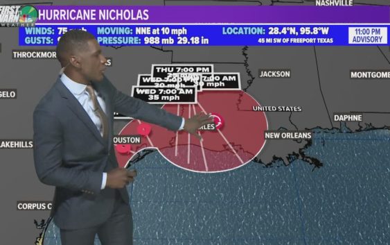
Hurricane Nicholas has made landfall about 10 miles WSW of Sargent Beach, Texas. Now set to bring life threatening flooding to the area
CHARLOTTE, N.C. —
Tropical Storm Nicholas
Nicholas upgrades to a hurricane in the Gulf of Mexico just off the Texas coast late Monday evening. The category one hurricane with maximum sustained winds of 75 mph is approaching landfall along the Texas coast near Houston. The 14th named storm formed Sunday as a tropical storm before intensifying in the warm waters of the Gulf.
Track:
Nicholas is expected to make landfall while on a northerly track, then make a slow turn eastward and crawl across Louisiana. Hurricane force-winds and storm surge likely impacts, but flash flooding will be tremendous from this system. Nicholas consequently will affect areas that got plagued in 2017 from Harvey and for parts of Louisiana that are more recently, recovering from Ida.
Main Threat: Heavy rain and Flooding
Regardless of its strength, the biggest threat is rainfall and flooding. The forecast track shows the slow forward speed and how the tropical system will position itself over the region for several days. The slow pace like will bring 10-15″ for a lot of communities over 2-3 days with some closer to 20″ by the end of this event.
Storm Surge:
The combination of high tide and storm surge will allow for a water level rise of 3 to 5 feet from the mouth of the Rio Grande to High Island, Texas, Baffin Bay, Corpus Christi Bay, Aransas Bay, San Antonio Bay, Matagorda Bay, and Galveston Bay.
A Storm Surge Watch is in effect for coastal areas near Houston, and a Storm Surge Warning is in effect for the Texas coastline.
Invest 95-L
This first wave is located off the coast of Africa. The tropical disturbance is moving on a westward path. There’s a 80% chance it will develop into a tropical depression or storm over the next two to five days when it drives into more favorable conditions. It will be a long wait until this gets close to anything but since it is marching due west, it could become one to watch by this time next week.
Invest 97-L
Gradual development is possible and the National Hurricane Center is giving it a 50% chance of development over the next two to five days.
This will be dangerously close to the Carolinas, but we have some things working in our favor. Long-term forecast models indicate the system will stay away from the United States east coast due to a strong ridge of high pressure and approaching cold front. This is subject to change, so we’ll monitor closely.
The next two names on the 2021 Atlantic hurricane list are Odette and Peter.