- South and Midwest face potentially catastrophic rains and floods while reeling from tornadoes
- Deadly 2024 hurricanes prompt WMO to retire three names
- Body recovered in North Carolina identified as East TN man who has been missing ever since Hurricane Helene
- Report: Coastal flooding could threaten 1.4 million homes by midcentury
- Caught on camera | Tornado touches down in Missouri
Tracking Nicholas, now a Hurricane, plus chances of development in the Atlantic

Part of the Texas coast has been upgraded to a Hurricane Warning in light of the upgrade, according to the National Hurricane Center.
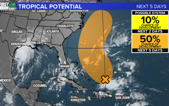
CHARLOTTE, N.C. — A medium chance for a tropical depression or storm to form in the southwest Atlantic over the next five days.
The potential for tropical development is historically higher during the middle of September due to favorable environmental conditions. While Tropical Storm Nicholas is bearing down on parts of the Gulf coast with potentially significant flooding to impact the region, there are two other areas of concern in the Atlantic.
Notice the clouds on the satellite image near Hispaniola, models are indicating the convection could become better organized off the Carolina coast later this week as it moves to the northwest. Right now, the chance of development is 10% over the next 48 hours and 50% over the next five days.
There are a couple of factors to consider when thinking what could happen next if it does form. First, high pressure to the east of the area of concern will help steer the system in a clockwise fashion away from the immediate coast of North Carolina. However, some moisture could move ashore with widely scattered rain by mid/late week. No direct impacts are likely for us. In addition, the approaching cold front from the west will also play a role in keeping any impacts very low. We will continue to keep you updated on this system as well the tropical wave currently moving off the coast of Africa.