- South and Midwest face potentially catastrophic rains and floods while reeling from tornadoes
- Deadly 2024 hurricanes prompt WMO to retire three names
- Body recovered in North Carolina identified as East TN man who has been missing ever since Hurricane Helene
- Report: Coastal flooding could threaten 1.4 million homes by midcentury
- Caught on camera | Tornado touches down in Missouri
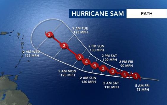
Hurricane Sam forms, too early to determine if it will impact US

Hurricane Sam formed Friday morning and is forecast to become a major hurricane by 8 a.m. Saturday.
At 5 a.m., Sam was a Cat. 1 hurricane moving west at 15 mph with maximum sustained winds at 75 mph.
“Sam will continue to intensify,” explained WRAL meteorologist Zach Maloch.
According to Maloch, many models show a turn to the north by later next week, but some models keep Sam a little farther south, which means it has a better chance of passing between the Carolinas and Bermuda.
“Most models keep it just east of the U.S., but there could be some coastal impacts for next weekend,” Maloch said. “Timing could change. Simply we are in the watching stage.”
Meteorologists are also watching three other areas of interest that have low to medium chances of development and shouldn’t impact land.