- Fake job seekers are flooding the market, thanks to AI
- One set of evacuation orders lifted in Caldwell County after wildfire contained
- 'We gutted every building' | Chimney Rock rebuilding after Hurricane Helene
- 'We gutted every building' | Chimney Rock rebuilding after Hurricane Helene
- Debris from Hurricane Helene provides fuel, complicates containment for spring wildfires
Flash Flood Watch issued for San Antonio on Wednesday as Hurricane Pamela strengthens
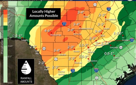
A Flash Flood Watch goes into effect Tuesday nights for parts of the Edwards Plateau and Rio Grande Plains. On Wednesday morning, the watch expands to include the Hill Country and San Antonio.
Forecasters predict areas could see two to fives inches of rain, with higher totals possible.
“The greatest threat for this is currently forecast to be across the Hill Country, southern Edwards Plateau, and Rio Grande,” the National Weather Service says.
San Antonio could see one and half to two inches of rain.
National Weather Service
As of Tuesday morning, San Antonio is expected to see around one and a half to two inches of rain.
“It should be stressed that this is a fluid forecast and adjustments are still possible on where the axis of higher rainfall amounts occur,” the NWS says.
The storms are a result of the remnants of Hurricane Pamela absorbing into an upper level storm system across South Central Texas and combining with Gulf moisture.
Pamela is expected to reach near major hurricane strength before making landfall in Mexico Wednesday morning. According to the National Hurricane Center, heavy rains associated with Pamela are expected across Texas late Wednesday and Thursday.

A Flash Flood Watch goes in effect for San Antonio Wednesday morning.
National Weather Service
San Antonio will see rain chances increase through Thursday, NWS says.
National Weather Service
Rain changes diminish throughout the week and into the weekend.
National Weather Service