- Western NC neighborhood still reeling from Hurricane Helene flood damage
- Ashe County Schools reopen after Hurricane Helene hit area over a month ago
- Ashe County Schools reopen Tuesday after Hurricane Helene hit area
- Carolina Hurricanes foundation donates $50,000 to rebuild Asheville hockey rink
- Stress, shelter, and safety: Hurricane Helene's effect on domestic violence victims in NC
Flooding possible as storms from Tropical Depression Pamela moves across South Texas | Track the rain

Parts of South Texas may get more than four inches of rain, which could lead to flooding.
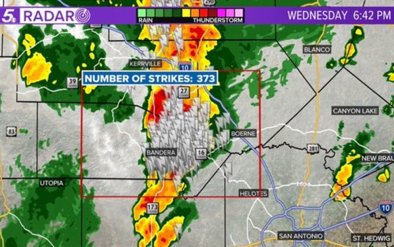
SAN ANTONIO — An intense thunderstorm with frequent lightning, heavy rain, and strong wind is moving toward western Kendall and southeast Kerr counties from Bandera County as of 6:45 p.m. KENS 5 Meteorologist Andrew Wilson says to head indoors if you are in this region.
A Severe Thunderstorm Warning for portions of Gillespie, Kerr and Bandera counties expired at 6:30 p.m. Previously, a Severe Thunderstorm Warning issued for parts of Uvalde, Real, Bandera and Kerr counties expired at 5:45 p.m.
Heavy rain arrived in parts of South Texas Wednesday afternoon and it is forecast to continue through this evening with a Flash Flood Watch in place until 7 p.m. on Thursday.
While the Flash Flood Watch will continue until late tomorrow afternoon, the heaviest of the rain is forecast for South Texas from 8 p.m. Wednesday through 2 a.m. on Thursday.
The heaviest rain in San Antonio and along the I-35 corridor will likely occur between 9 p.m. and 11 p.m.
All of the rain is being driven by deep tropical moisture surging over the region from Mexico as Tropical Depression Pamela weakens and the remnants of the system move over South Texas.
Any rain that does occur tonight will likely be very heavy due to the amount of moisture within the profile of the atmosphere.
Expect lingering showers and storms during the morning on Thursday, but drier conditions will move in for the afternoon.
For the seven-day rainfall forecast, we are expecting four to six inches of rain in parts of the Texas Hill Country with other parts of the region experiencing one to three inches of rain. Nearly all of this rainfall is forecast to occur within the next 24-hours.
After Thursday, we will have the possibility of one more brief period of rain for Friday as a cold front sweeps across the Lone Star State.
Drier, cooler air will move in behind the front and temperatures will be in the 40s to 50s for lows and 70s for highs under a mostly clear sky throughout the weekend and into the early part of next week.