- As wildfires grip South Carolina, governor warns: Burn and you’ll go to jail
- Hundreds of brush fires burn across North Carolina Saturday; several fires still burning Sunday
- Texas’ biggest wildfire started a year ago. How does the Panhandle look now?
- To her, Hurricane Helene debris isn’t trash. It is full of memories — and she’s returning them
- Bills introduced a year after state’s largest blaze seek to limit wildfires
Snow flurries, frigid temps follow severe weather system
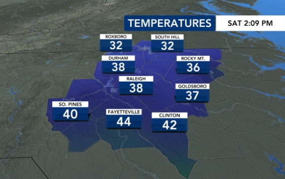
Raleigh, N.C. — After storms moved out of Raleigh on Saturday, temperatures dropped. By the end of the day, temperatures are expected to be in the low 30s with a wind chill making it feel even cooler.
“Arctic air is going to move through. We have some cold air behind this very strong front,” according to WRAL meteorologist Aimee Wilmoth.
Temperatures will continue to fall throughout the day. At 4 a.m. on Saturday it was 56 degrees outside. By the afternoon, temperatures had dropped to the upper 30s and overnight it will be in the low 20s.
Some people reported seeing flurries across the Triangle on Saturday afternoon. Communities near both the North Carolina-Virginia line also saw a light dusting of snow.

Sunday morning is expected to be the coldest March morning the Triangle has seen since 2015.

Some people hate Daylight Saving Time while others love it. It may mess with your sleep schedule, but beginning Sunday, the sun will set an hour later, closer to 7:30 p.m. than 6:30 p.m. By the summer solstice, the sun won’t set until after 8:30 p.m.
While temperatures will start off in the teens and 20s, temperatures will rebound for Sunday afternoon, with highs in the upper 40s and lower 50s and plenty of sunshine expected.
Storm moves out of central NC, leaving behind downed trees and power outages

A line of severe thunderstorms moved across central North Carolina early Saturday morning. Heavy rain, strong wind gusts and lightning were spotted across the state as the band of storms moved east, from the Triad to the coast.
Strong winds and rain from the storm knocked over several trees and power lines across central North Carolina on Saturday morning, causing roads to be clogged and people to lose power. Thousands of people were waking up without power in Durham, Franklin and Wake counties.

A Tornado Watch was issued for several eastern North Carolina counties, including Sampson. WRAL’s team of meteorologist said there was a “slim chance” for a tornado in communities near Goldsboro, Lumberton, Greenville and New Bern. The watch expired around 9:30 a.m.
Wake County was also under a flood advisory on Saturday morning. Around an inch of rain fell in the Triangle causing many trees to fall down.
Winds were gusting to 25 mph in Raleigh and 36 mph in Fayetteville at around 5 a.m. Even after storms move out of the Triangle, wind gusts are expected to reach more than 50 mph on Saturday afternoon.

A large tree fell on a house off Chatham Forest Drive in Chatham County early Saturday morning. The homeowner said his 5-year-old daughter was asleep in her bedroom when the tree crashed through her ceiling. Thankfully, no one was hurt.
The storm’s strong winds brought down multiple power lines onto a Johnston County roadway and brought a large tree down in Sampson County.

Several trees were reported down in Raleigh at Lake Wheeler Road one tree fell on a power line on Smithfield Road in Knightdale. One Raleigh family told WRAL News that a tree fell on their camper on Graham Newton Road, totaling it.