- Hundreds of brush fires burn across North Carolina Saturday; several fires still burning Sunday
- Texas’ biggest wildfire started a year ago. How does the Panhandle look now?
- To her, Hurricane Helene debris isn’t trash. It is full of memories — and she’s returning them
- Bills introduced a year after state’s largest blaze seek to limit wildfires
- A year after Texas’ largest wildfire, Panhandle residents tugged between hope and anxiety
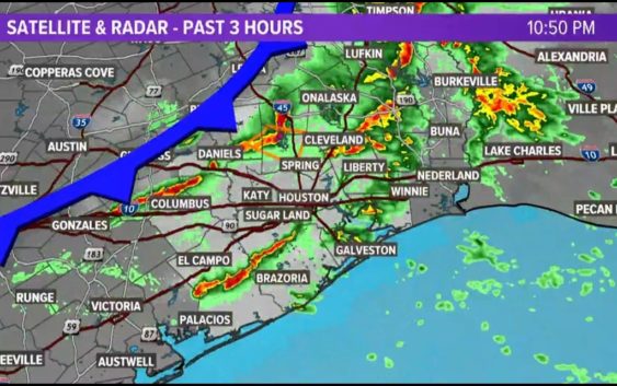
Tornado Warning issued for Liberty County until 11:45 p.m.
This cold front won’t drop temperatures much, but it is bringing thunderstorms late Monday night and early Tuesday.
HOUSTON — A line of storms is moving across the Houston area as front passes through our area. A front is moving through the Houston carries on as we enter a new week here across Southeast Texas.
This next one, however, will be a bit different from the past few we’ve experienced. How so? Well, for starters it won’t be getting all that cold, that’s a positive.
But as the front barrels in from the northwest, it will run into a marginally unstable environment that may be supportive of some strong to severe thunderstorms Monday night.
A Tornado Warning was issued for Liberty County until 11:45 p.m. The National Weather Service said a severe thunderstorm capable of producing a tornado was located 8 miles southwest of Votaw.
Watch the 10 p.m. weather update from the KHOU 11 Weather Team below:
Details
The Storm Prediction Center has kept our area in the Level 1 risk most of the Greater Houston Area, including coastal communities. It’s Level 2 for areas farther to the northeast, where the greatest likelihood looks to be for severe weather.
Cold front timeline
1 a.m. Tuesday: The cold front is moving through Harris County just after midnight with a line of strong thunderstorms with the potential of gusty winds and small hail.
3 a.m. Tuesday: The cold front is a fast mover and will be near the coast by this time, still likely producing strong thunderstorms with heavy rain, gusty winds and small hail.