- Hundreds of brush fires burn across North Carolina Saturday; several fires still burning Sunday
- Texas’ biggest wildfire started a year ago. How does the Panhandle look now?
- To her, Hurricane Helene debris isn’t trash. It is full of memories — and she’s returning them
- Bills introduced a year after state’s largest blaze seek to limit wildfires
- A year after Texas’ largest wildfire, Panhandle residents tugged between hope and anxiety
Austin weather: Confirmed tornado in Wimberley; several tornado warnings
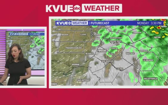
Much of Central Texas is under a moderate to severe weather threat tonight.
AUSTIN, Texas — It’s a day where we want you to pay close attention to the forecast and make sure you have a way to receive warnings. Rain showers Monday morning have transitioned to a threat for severe storms for the afternoon and evening. The window for severe storms is expected to last until 11 p.m. Monday.
Much of Central Texas is now included in the “moderate” – level 4 of 5 – risk for severe storms. Storms Monday afternoon into the evening will be capable of large hail, tornadoes and damaging winds. This includes the potential for large hail that could exceed two inches in diameter and also the potential for a strong, long-track tornado.
Here’s a live blog with tonight’s main updates:
6:02 p.m. – The Tornado Warning now includes Round Rock, Pflugerville and Taylor until 6:45 p.m.
5:56 p.m. – A ground confirmed tornado has been confirmed near Sun City. It’s moving NE at 30 mph. It’s approaching the Jarrell region.
5:55 p.m. – A Tornado Warning includes Jarrell in Williamson County until 6:15 p.m. If you live along Interstate 35, you want to make sure you are in or near your safe space.
5:47 p.m. – Here’s the timing of the tornado-warned storm:
5:43 p.m. – Austin and Buda residents should take cover. A Tornado Warning for the Austin area is in effect until 6:15 p.m.
The Tornado Warning covers Austin, Buda, Kyle, Lost Creek and Shady Hollow.
5:35 p.m. – A tornado has been confirmed by the National Weather Service in Wimberley. It is moving north.
5:20 p.m. – A Tornado Warning has been issued in the areas of Wimberley, Dripping Springs and Woodcreek until 5:45 p.m.
5:12 p.m. – A local storm report indicates egg size hail was observed near New Braunfels a few minutes ago.
5:10 p.m. – A Severe Thunderstorm Warning is in effect until 6 p.m. for portions of Blanco, Hays, Travis and Williamson counties. Gusts up to 60 mph and hail over an inch in diameter is possible.
4:56 p.m. – Local storm reports indicate ping pong ball size hail in Guadalupe County.
4:53 p.m. – There are now three Severe Thunderstorm Warnings now lined up west of Austin. All of these storms are capable of quarter size hail and wind gusts up to 60 mph.
4:46 p.m. – A Severe Thunderstorm Warning is in effect until 5:45 p.m. for portions of Bexar, Comal, Gonzales, Guadalupe and Hays counties.
SEVERE THUNDERSTORM WARNING: in effect until 5:45 PM for portions of Bexar, Comal, Gonzales, Guadalupe, and Hays counties. Gusts up to 60 mph and quarter size hail are possible within these storms. System is moving NE at 35 mph. #txwx pic.twitter.com/Pv6PE0sFrd
— Shane Hinton (@MakeItRainShane) March 21, 2022
4:24 p.m. – A Severe Thunderstorm Warning is in effect until 5:15 p.m. for Blanco, Burnet, Hays and Travis counties.
3:12 p.m. – A Tornado Watch is issued for the KVUE viewing area until 10 p.m.
Here’s a detailed breakdown of when the storms will develop and how we’re expecting the day to unfold across Central Texas:
Timeline: Severe storms could impact rush hour commute
There will be no issues with severe weather early in the day, but visibility could be reduced and roads could be slick, so take it easy.
By early afternoon, we may enter a brief lull in the activity as we wait on the severe through to begin for the mid and late afternoon.
By 3 p.m., the window for severe storms will open. At this time, a dryline will move into the Hill Country and this will be the trigger mechanism for strong to severe storms.
Storms will initially fire west of Austin and track quickly east. Keep in mind that storms could impact school pick-up for some areas. Please check in with the KVUE app prior to hitting the roads this afternoon.
Likewise, strengthening storms could be pushing across the Interstate 35 corridor during the peak rush hours commute. Please check in with the forecast before you leave the office. The last thing we want is anyone leaving work in a rush only to get stuck on the roads during a hail storm or in the patch of a tornado.
We’re expecting strong to severe storms pushing across much of the Austin metro between about 4 p.m. and 6 p.m. this afternoon.
Wait out the storms if you have to before hitting the roads. Storms will quickly push eastward through the late afternoon and early evening hours with the potential for hail, tornadoes and strong winds.
The window for severe storms will close at 11 p.m. as the main threat moves away to the east. Some additional rain or storms will be possible east of Austin overnight as a cold front pushes through but, at this time, we are not expecting any of this activity to be severe.
A few lingering showers Tuesday morning will give way to a sunny, breezy and cooler Tuesday afternoon. We do not have additional concerns for severe weather throughout the week.
Threats: Large hail, tornadoes, damaging winds all possible
Again, our main talking point is to make sure everyone is weather aware and has a way to get warnings. The main threat today will be the potential for large hail, but tornadoes and damaging winds are also possible.
The Storm Prediction Center is also indicating the possibility of significant hail and tornadoes. This means the potential for large hail of two inches or more in diameter and the potential for a strong, long-track tornado that could be of EF2 strength or higher.
This is our first significant severe weather threat of the season, so just make sure you’re prepared and have a plan to get weather alerts today.
The KVUE Storm Team will continue to closely monitor this developing forecast.
In the meantime, here is a look at your extended forecast: