- McDowell County wildfire spreads to 500 acres, evacuation orders in place
- Evacuations in Caldwell County due to wildfire
- Northwest Houston 'ghost neighborhood' caused by repeated flooding to become latest detention basin
- NHL playoffs: Hurricanes open playoffs Easter Sunday afternoon vs. Devils
- 2 wildfires spreading in rugged terrain in western North Carolina
Severe weather possible in the Carolinas Wednesday
Widespread rain and thunderstorms are possible across the Carolinas and Charlotte area Wednesday afternoon and evening. Some could even see tornadoes.
CHARLOTTE, N.C. — A strong storm system that’s produced widespread severe weather and tornadoes in Texas is now marching east with the threat of more severe storms in the Carolinas this week.
WCNC Charlotte meteorologist Chris Mulcahy says multiple tornadoes and severe thunderstorms are possible in the Southeast through Thursday morning as the system moves east toward the Carolinas.
Day 1 outlook (Tuesday and Tuesday night)
The area in pink below has the best chance for severe weather and tornadoes Tuesday. This area has prime conditions that will allow for a “twist” in the atmosphere and a lot of moisture to set up multiple severe storms.
Wind damage is expected across Louisiana, through Mississippi and into Alabama. The main threats Tuesday will be damaging winds but a tornado outbreak is possible.
Day 2: Carolinas impacted
The threat for severe storms will be lower than areas west of the Carolinas, but there is a low-to-moderate threat for severe storms Wednesday afternoon and evening. This is the best Charlotte for severe weather thus far in 2022.
All areas in North Carolina and South Carolina will be at risk for strong storms, including Charlotte, Concord, Fort Mill, Gastonia, Lincolnton, Monroe, Mooresville, Rock Hill, Salisbury, Statesville and Waxhaw.
Timing
The window is loosely open from late morning until the early evening. Right now, the best opportunity for severe storms and tornadoes for the Charlotte area will be from noon Wednesday until around 6 p.m.
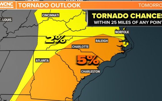
Tornado threat
A 5% chance is much lower than the 10-15% chance areas out west have had, but it only takes one to make the difference. There will be a lot of wind shear to the atmosphere that allows for storms to rotate. The worst scenario would be isolated rotating thunderstorms (supercells) that are typically stronger and have better chances to produce tornadoes.
Wind threat
The wind threat is at 15%, which means that roughly 1 out of every 6 thunderstorms could produce damaging wind gusts exceeding 58 mph. Regardless of any thunderstorms, this approaching front will drive up the winds.
Winds will be gusting from 20-35 mph for most of the area. These winds will be even higher in the mountains. We can blame the low-level jet on this. This jet stream is about a mile up and it will be blasting some very warm and unstable winds aloft. This will also add that twist to the atmosphere mentioned above.
Flooding Threat
This threat diminishes compared to the threats over the last couple of days, but these strong thunderstorms could produce a lot of rain that would lead to some localized and urban flooding. Up to 2 inches of rain is possible for some locations in the Charlotte area.