- California homeowners face potential hikes as State Farm defends wildfire rate increase
- After Hurricane Beryl, Texas lawmakers push for generators at senior living facilities
- 20-million-gallon detention basin in Meyerland designed to help prevent flooding
- Firefighters report significant progress on McDowell County wildfire
- How to watch the FireAid benefit concert for LA wildfire relief
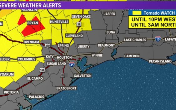
Tornado Watch for several Houston-area counties until 3 a.m. | Timeline of severe weather
The threat for severe weather across Southeast Texas is expected to continue through the night with the possibility of tornadoes, hail and flash flooding.
HOUSTON — The threat for severe weather across Southeast Texas will continue Monday night into Tuesday morning. It’s bringing the possibility of tornadoes, hail and flash flooding.
Severe Weather Alerts
A Tornado Warning was extended for parts of Grimes, Houston and Madison counties until 10:30 p.m. Monday.
A Tornado Watch has been issued until 10 p.m. for Austin, Brazos, Burleson, Colorado, Grimes, Madison, and Washington counties. According to Meteorologist Tim Pandajis, that could be expanded east, more into the Houston area.
Another Tornado Watch was issued for Montgomery, Walker, San Jacinto, Trinity, Liberty and Polk, along with several other Southeast Texas counties, until 3 a.m.
Tornado reports
At 9:44 p.m., spotters observed a tornado on the ground on US 190 on the southwestern side of Madisonville moving northeast at approximately 40 mph. Spotters report debris and vehicles that were caught in the path. Downed trees and power lines were also seen across the highway.
This video was recorded in Round Rock by our sister station, KVUE:
This is from Jacksboro, Texas, about 60 miles northwest of Fort Worth. This video is from our sister station, WFAA:
Timeline
Most computer models show the front slowing down, so the timing has shifted to later Monday night into Tuesday morning.
The flash flooding threat ramps up in the early morning hours on Tuesday and into the morning rush hour.
“I think some of the bayous may react and spill, at least partially as we head into the overnight,” KHOU 11 Chief Meteorologist David Paul said.
LIVE RADAR: Track the storms as they roll into SE Texas
As the front moves through, hail, damaging winds upwards of 60 mph, isolated tornadoes and heavy downpours are capable of producing flash flooding.
That is why we have a Flash Flood Watch in effect and it’s expected to become a Flash Flood Warning later Monday night or early Tuesday morning.
Paul said early models predict 2 to 4 inches of rain for many areas, but that could quickly go up to 5 or 6 inches.
Here’s a look at the timing of the storms
Monday 11 p.m.: Storms are becoming a bit stronger, the severe threat is increasing during this time with damaging winds, large hail, flooding downpours and isolated tornadoes becoming more prominent as an advancing dryline acts to instigate the atmosphere and produce a more defined line of strong storms.
Monday 12 a.m.: Round 2 of the thunderstorms roll through around midnight through the early morning rush hour Tuesday across the Greater Houston area.
“We could see the biggest flooding threat as the torrential rain just sits over the same areas for an extended period of time. And that’s going to put down 3, 4, 5 inches of rain in just a few hours,” warned KHOU 11 Meteorologist Pat Cavlin.
Tuesday 2 a.m.: The advancing dryline ignites more strong storms with the potential of supercells developing and pivoting slowly through our western cities and counties. Threat significantly increases for tornadoes, damaging winds, large hail and flash flooding.
Tuesday 5 a.m.: The dryline thunderstorms diminish but the cold front fires off a more defined squall line moving into our western cities and counties in the very early morning hours of Tuesday. The flash flooding threat is significantly increased as the line is slow to move and will deliver 2 to 3 inches per hour rainfall rates. Overnight tornado, damaging wind and large hail threats continue to be high.
Tuesday 8 a.m.: The cold front is pushing through the Houston metro in the middle of the morning commute Tuesday. Blinding, flooding downpours with flash flooding likely with this slow-moving squall line. Embedded tornadoes, damaging straight-line winds and large hail is also possible.
Tuesday 10 a.m.: The passing of the cold front won’t happen until later tomorrow morning. The majority of the severe storms have now pushed east of I-45 and improving conditions begin to work into our area. Most areas are out of the woods in terms of a severe threat at this time.
Stay close to the forecast and the weather team at KHOU 11 News for the latest changes and up-to-date information. With the threat coming in overnight, it is even more important to exercise your storm plan now and be ready at a moment’s notice to seek a safe place if a tornado warning is issued for your area or flash flooding breaks out. Download the KHOU 11 News app to receive all alerts immediately to your phone.
KHOU 11 APP: Get our mobile weather alerts
Click here to track the rain using our live radar.
KHOU 11 RADAR: Track Houston storms and rain here