- Fake job seekers are flooding the market, thanks to AI
- One set of evacuation orders lifted in Caldwell County after wildfire contained
- 'We gutted every building' | Chimney Rock rebuilding after Hurricane Helene
- 'We gutted every building' | Chimney Rock rebuilding after Hurricane Helene
- Debris from Hurricane Helene provides fuel, complicates containment for spring wildfires
Panovich: Signs are pointing to severe weather Wednesday evening

Widespread rain and thunderstorms are possible across the Carolinas and Charlotte area Wednesday afternoon and evening. Some could even see tornadoes.
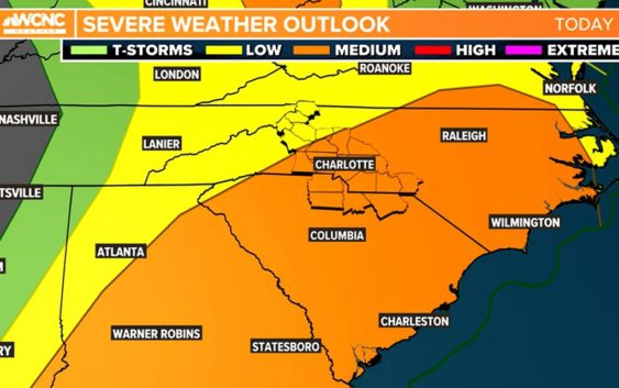
CHARLOTTE, N.C. — The Charlotte area will be at risk for severe weather Wednesday afternoon and evening, with the possibility of strong storms, chief meteorologist Brad Panovich said.
Panovich is tracking a line of storms and a cold front moving across Tennessee that will reach the Carolinas Wednesday afternoon. Panovich said that line is something to watch because there is some instability in the atmosphere, creating the ingredients for strong thunderstorms.
Those ingredients include rising humidity from a warm front that’s moving north. Panovich said that warm air will move in after the first wave of rain passed through Wednesday morning. That warm air, combined with the heating of the day, could create instability and a risk for severe weather.
“Even though we’re really stable here, the fact that some warm air is getting pulled up ahead of the main front is something that we need to watch,” Panovich said. “That potentially could lead to some strong storms.”
Panovich said he’s also monitoring the Significant Tornado Parameters, which measures the potential for rotation in storms, as well as the supercell parameter from the Storm Prediction Center.
Timing
By 3 p.m., storms will begin to push into the Charlotte metro area. This would include the cities of Shelby, Morganton, Gastonia and Lincolnton in North Carolina. Those storms will continue to march east into Charlotte and toward Union County, including the cities and towns of Indian Trail, Monroe and Waxhaw.
“These could be supercells, these are ones you definitely got to watch, right around 5, 6 o’clock, pushing through,” Panovich said. “So while not overwhelming support for severe weather, the fact we’ve got some of these isolated cells this evening is something to watch.”
The good news is the widespread rain in the Carolinas Wednesday morning has calmed the atmosphere down. At the very least, rain delayed the start of any severe potential by stabilizing the atmosphere.
“If we’re going to see rotating storms or supercells, it’s that timeframe from 5 p.m. until around 8 p.m.,” Panovich said. “Likely what’s going to happen is the rain that’s over us this morning, keeps us stable. And when we go into the afternoon, the warm front is surged up here pushing warm, humid air to the north, and then the cold front comes through and there’s a narrow band of instability that kicks off those showers and storms.”
Tornado threat
A 5% chance is much lower than the 10-15% chance areas out west have had, but it only takes one to make the difference. There will be a lot of wind shear to the atmosphere that allows for storms to rotate. The worst scenario would be isolated rotating thunderstorms (supercells) that are typically stronger and have better chances to produce tornadoes.
Wind threat
The wind threat is at 15%, which means that roughly 1 out of every 6 thunderstorms could produce damaging wind gusts exceeding 58 mph. Regardless of any thunderstorms, this approaching front will drive up the winds.
Winds will be gusting from 25-40 mph for most of the area. These winds will be even higher in the mountains. We can blame the low-level jet on this. This jet stream is about a mile up and it will be blasting some very warm and unstable winds aloft. This will also add that twist to the atmosphere mentioned above.
Flooding Threat
This threat diminishes compared to the threats over the last couple of days, but these strong thunderstorms could produce a lot of rain that would lead to some localized and urban flooding. Up to 2 inches of rain is possible for some locations in the Charlotte area.