- Fake job seekers are flooding the market, thanks to AI
- One set of evacuation orders lifted in Caldwell County after wildfire contained
- 'We gutted every building' | Chimney Rock rebuilding after Hurricane Helene
- 'We gutted every building' | Chimney Rock rebuilding after Hurricane Helene
- Debris from Hurricane Helene provides fuel, complicates containment for spring wildfires
System dropping tornadoes across the Deep South headed towards central NC — threat not expected to be as severe
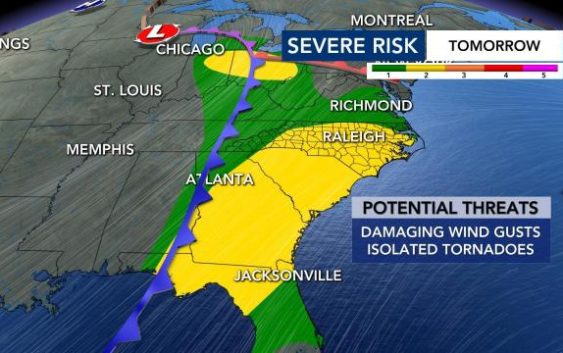
Raleigh, N.C. — A line of strong storms, which has dropped tornadoes across Texas and the Deep South, over the past two days, is making its way towards North Carolina.
While the same system will move through the area, WRAL meteorologist Kat Campbell said the severe weather threat will not be as high or widespread because our atmosphere is less energized and the strongest forcing will be displaced north of N.C.
“Most of our viewing area remains under a Level 2 out of 5 threat for severe weather as opposed to the Level 3 risks that produced several tornados in recent days,” said Campbell.
Damaging wind gusts and localized floodings will be the main concerns in central N.C. on Wednesday, but an isolated tornado and hail are possible.
Storms are expected to arrive around 4 p.m. and will last at least through midnight, Campbell said, with up to 1 inch of rain possible.
“New high-resolution data shows showers moving from the west between 10 a.m. and 3 p.m. Wednesday,” said Campbell.
Outside of the rain, Wednesday will be mostly cloud with highs in the 70s.

The storms should move away Thursday morning, but a Level 1 low risk goes into effect for eastern North Carolina, where wind damage is possible. There could be some lingering rain throughout the afternoon, but the storm risk is largely overnight.
Temperatures will be cooler, in the 60s, for Friday and Saturday. On Sunday, highs will be in the upper 50s. The weekend should be clear, and we could be close to freezing Monday morning, when lows drop into the lower 30s.

Eager to get the garden going?
Wondering if it’s okay to start planting? Temperatures will stay spring-like for a while, but cooler temperatures are ahead. We’re expecting cooler than average temperatures next week, according to meteorologists.

Our average last freeze comes in mid-April.