- South Carolina's governor declares State of Emergency as massive wildfire grows to 1,600 acres
- Staying weather alert: How to find your safe place during severe weather
- Wildfires persist across Carolinas amid windy, dry conditions
- York County crews help battle South Carolina wildfires
- Crews battle wildfires in North and South Carolina amid dry conditions and gusty winds
Tornado warning issued for parts of Triad

Raleigh, N.C. — A tornado warning is in effect for parts of Davidson, Guilford and Randolph counties until 5:15 p.m. The National Weather Service said at 4:30 p.m. a thunderstorm capable of producing a tornado was located 8 miles east of Thomasville.
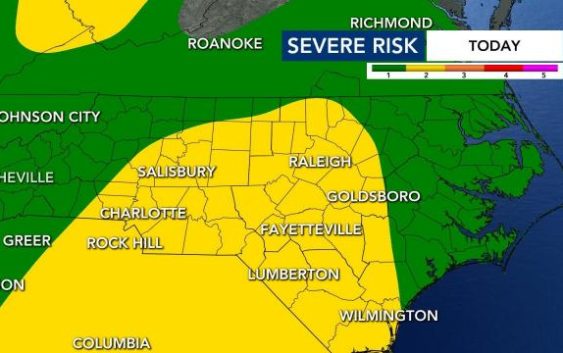
Most of the state is under a Level 2 risk for severe weather beginning Wednesday afternoon as a system that has spawned tornadoes across the Deep South moves into the area.
Scattered showers and storms will move across North Carolina this afternoon and through the evening – even impacting parts of the state overnight and into Thursday.
WRAL meteorologist Kat Campbell said storms are moving to the northeast as of 4:45 p.m. at 45 miles per hour. The system could close in on the Hillsborough area around 5:40 p.m. and Durham around 5:53 p.m.
This means there’s potential for strong or severe storms to impact your area during both the evening commute Wednesday and morning commute Thursday.
The biggest threats will be isolated tornadoes, damaging wind gusts and pockets of heavy rain. Between 1-2″ of rain will be possible between today and Thursday at noon.
Although the storm system is the same system that moved through the Deep South, the severe weather threat will not be as high or widespread because our atmosphere is less energized.
“We don’t have the core of the energy like Mississippi, Louisiana and Texas had in the previous days but we still need to watch for an isolated storm,” said Campbell.
Two people were killed as the storm front blew across the southeast.
“Damaging winds would be the most likely risk,” said WRAL meteorologist Elizabeth Gardner.
The tornadoes that have impacted the Deep South won’t be as large of a threat. Additionally, we won’t see much lightning from these storms.
“It’s not a zero threat, but we’re not looking at a widespread tornado outbreak here,” Gardner said.
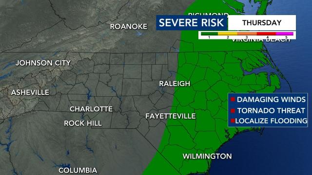
The storms should move away Thursday morning, but a Level 1 low risk goes into effect for eastern North Carolina, where wind damage is possible. There could be some lingering rain throughout the afternoon, but the storm risk is largely contained to Wednesday night and Thursday morning.
The storms aren’t as likely to be severe on Thursday.
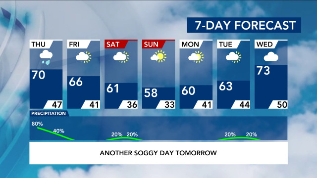
Temperatures will be cooler, in the 60s, for Friday and Saturday. On Sunday, highs will be in the upper 50s. The weekend should be clear, and we could be close to freezing Monday morning, when lows drop into the lower 30s.
Eager to get the garden going?
Wondering if it’s okay to start planting? Temperatures will stay spring-like for a while, but cooler temperatures are ahead. We’re expecting cooler than average temperatures next week, according to meteorologists.
Our average last freeze comes in mid-April.


