- NC Gov. Stein pledges continued Hurricane Helene recovery support in 100-day address
- Austin adopts new map that greatly expands area at risk of wildfire
- CenterPoint Energy accelerates infrastructure improvements ahead of hurricane season
- Carolina Hurricanes playoff tickets go on sale Thursday
- Ask the Meteorologist: Why do tornadoes target Tornado Alley, Dixie Alley?
Severe storms in Deep South could bring damaging winds, heavy rain to NC
Raleigh, N.C. — After some cooler days, spring warmth returns Wednesday, but severe weather is possible by Thursday afternoon.
Highs will be in the mid 60s on Wednesday. The day will be cloudy but mostly dry, with just a small chance for rain.
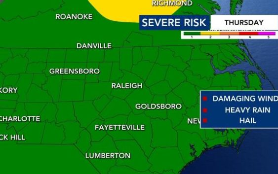
Thursday will be warmer, with a high in the low 70s. Storms will be possible Thursday afternoon and evening, and some could become strong to severe. There is a Level 1 risk for severe weather across North Carolina.
WRAL meteorologist Elizabeth Gardner said rain and storms could arrive in the Triangle by noon on Thursday, but most of the activity should be over by the evening commute.
Storms could continue later along the Interstate 95 corridor, and anyone could see a sprinkle or two into the evening, she said. Wind damage and heavy rain will be the biggest threats, and the risk for isolated tornadoes is low. Up to 1 inch of rain is possible.

Storms will impact the Deep South on Wednesday, where a Level 4 risk for severe weather is in place. That same storm system will impact N.C. on Thursday, but we don’t have the same serious threat here.
 but a few strong tornadoes (EF2+) are likely as well.")
New Orleans is under the threat for severe weather between 6 and 9 p.m., which could impact travel for people heading that way ahead of Saturday’s game.

Friday and the weekend will be beautiful, with mostly clear skies and highs in the low 70s (Friday) and mid to upper 60s (Saturday and Sunday).