- NC's FEMA aid extension for Hurricane Helene recovery denied
- NC's FEMA aid extension for Hurricane Helene recovery denied
- NC Gov. Stein pledges continued Hurricane Helene recovery support in 100-day address
- Austin adopts new map that greatly expands area at risk of wildfire
- CenterPoint Energy accelerates infrastructure improvements ahead of hurricane season
Forecast: A few storms Monday morning; severe weather threat for both Monday and Tuesday

Here are the latest updates from the KVUE Storm Team.
AUSTIN, Texas — You may be waking up to the sound of thunder this morning, as we’ve been tracking some strong storms across Central Texas overnight. A few widely isolated strong storms remain possible through the predawn hours. These storms could produce small hail and gusty winds in addition to heavy rain and lightning but, for the most part, they have stayed under severe limits.
Lingering clouds through mid-morning will give way to a sunny and hot afternoon with highs in the upper 80s to near 90. There is a low chance for a couple of severe storms this afternoon and evening. The Storm Prediction Center has much of the KVUE area in the level 1 of 5 threat.
There will be a “cap” in the atmosphere that may prevent any storms from forming. However, any storms that do develop could quickly become severe with large hail and wind. Right now, we think the chance of storms forming this afternoon is about 20%.
The same setup will remain on Tuesday, but we think there will be a slightly higher chance of storms breaking through this “cap” in the atmosphere, especially north of Austin. The Storm Prediction Center now includes much of Central Texas in the level 2 and 3 threat for Tuesday afternoon and evening.
Again, it’s possible storms won’t form, but if they do they will quickly strengthen and could produce large hail, damaging winds and a few tornadoes.
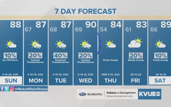
A cold front will sweep through on Wednesday and put an end to the severe storm threat for a while after the morning hours. Afternoon highs briefly drop back to the 80s for Thursday and Friday.
Then over the Easter weekend, we’re looking ahead to some pretty scorching April temperatures. The current forecast calls for low to mid-90s Saturday, and then mid to upper 90s on Easter.
MONDAY:
Morning clouds, then sunny and warm. 20% chance of strong storms. South wind at 10 to 15 mph with gusts up to 25 mph.
HIGH: 89
TUESDAY:
Morning clouds, then sunny and hot. 30% chance of severe storms. South wind at 10 to 15 mph with gusts up to 30 mph.
HIGH: 93
SEVEN-DAY FORECAST:
RELATED: Today’s Allergy Report
Check out the live radar for what you can expect the rest of the day and into the workweek.