- 'We gutted every building' | Chimney Rock rebuilding after Hurricane Helene
- 'We gutted every building' | Chimney Rock rebuilding after Hurricane Helene
- Debris from Hurricane Helene provides fuel, complicates containment for spring wildfires
- David & Nicole Tepper increase Hurricane Helene relief commitment to $750k
- David & Nicole Tepper increase Hurricane Helene relief commitment to $750k
Tornado warning active for Charlote area counties

Parts of Alexander, Burke, Caldwell & Catawba counties are under a tornado warning through 5:45 p.m. Wednesday.
CHARLOTTE, N.C. — Five Charlotte-area counties are under a tornado warning Thursday evening.
Alexander County, Burke County, Caldwell County and Catawba Conuty are all under a warning issued by the National Weather Service (NWS) that’s due to expire at 5:45 p.m. Cleveland County is under a warning that should expire closer to 5:30 p.m. Lincoln County’s warning was canceled at 5:15 p.m.
Residents in these areas are urged to seek shelter now. Ensure you have a battery-powered radio, supplies, and chargers in your safe zone. If you’re curious about how to find a safe place, here’s a good guide.
If you safely take photos or videos of the severe storms in your area, use the Near Me feature in WCNC Charlotte’s app to send them to us or text them to 704-329-3600. Just make sure to say where you took the photo or video so WCNC Charlotte Weather Team’s Chief Meteorologist Brad Panovich can add it to his reporting.
PHOTOS: A look outside as tornado warnings crossed the Charlotte area May 26, 2022
Northwestern Gaston County and western Lincoln County were both under a tornado warning during this string of severe afternoon storms, but that warning expired at 5 p.m.
The WCNC Charlotte Weather Team wants you to stay safe and informed when there are Weather Aware days like Thursday. Continue to pay close attention to our newscasts, app and streaming platforms when severe weather is in your area.
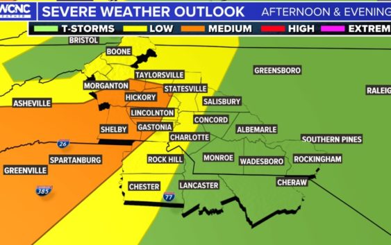
The Charlotte region will be at risk for two waves of severe weather Thursday and Friday, with the threat of damaging winds, isolated tornadoes and flash flooding, according to Chief Meteorologist Brad Panovich.
During a weather vlog Panovich posted Thursday morning, he expressed the two waves’ setup had him concerned about storms that could become severe.
“The problem is we have warm, humid air coming from the south,” Panovich said during his vlog Thursday morning. “What happens is later today, if the atmosphere destabilizes (which means sunshine), and we’re seeing some of that, down here in South Carolina, storms that develop along this front could be severe, especially closer to the mountains.”
Panovich said most of western North Carolina and South Carolina are under a low or medium risk for severe weather Thursday, with the medium risk extending toward Hickory, North Carolina. Panovich forecast that storms that move into the foothills and I-40 corridor could be strong Thursday evening around dinnertime.
“Let’s look at tornado probabilities,” Panovich said during his vlog Thursday morning. ” It’s still 2%, but I think that’s a little low. I actually think it’s more like 5% in the area west of Charlotte to Hickory to Asheville and down to Greenville, South Carolina.”
Cherokee County, which is in South Carolina, is also under a tornado warning until 5:30 p.m.
Storm timing
Panovich said heavy rain would move into the North Carolina mountains by 2 p.m. Thursday. These storms will produce downpours capable of causing flash flooding in addition to any severe weather.
“Flash flooding is going to be an issue because, throughout the day, you’re going to see waves and waves of precipitation and thunderstorms,” Panovich said.
Panovich expects storms to move toward Hickory around 6 p.m., and there’s a chance some become severe. By 9 p.m., those storms will move into the Charlotte area and along I-77 from Mount Airy, North Carolina, to Columbia, South Carolina.
“After dinnertime tonight, that’s the timeframe to watch,” he said. “There is a little bit of a hint of some rotational tracks there at 9 p.m. Honestly, that’s not off the charts, that doesn’t look anything as bad as it did on Monday as far as rotation.”
Two tornadoes touched down in the Charlotte area during Monday’s severe weather outbreak, including one near Reedy Creek in Mecklenburg County. Friday’s storms are more likely to be severe due to the timing, Panovich said.
“We’ll get some heating of the day and it gets a little stuck,” Panovich said of the line. “That’s a squall line that looks strong, maybe too severe, maybe some supercells developing in eastern North Carolina.”
The severe weather threat on Friday will be east of I-77 toward the Coast, Panovich said. Back toward Charlotte, Panovich expects some pop-up storms capable of producing hail but he doesn’t anticipate they’ll be particularly severe.
Contact Brad Panovich at bpanovich@wcnc.com or follow him on Facebook, Twitter and Instagram.