- Artists transform hurricane aftermath into hoop-inspired masterpieces at Charlotte exhibit
- NC's cost for Hurricane Helene damage is nearly $60 billion, state says
- State to develop drone program to better respond to disasters like Helene, Florence
- South Carolina residents face deadline to get storm debris out to the curb after Hurricane Helene
- SCDOT to pick up Hurricane Helene debris for a final day in South Carolina
From parched to drenched: Flooding possible this week as heavy rains move in

Following months of extreme drought and triple-digit temperatures, San Antonio may now face possible flash floods this week as heavy rains move into the Central Texas area.
Drought and flooding aren’t unrelated, said National Weather Service Meteorologist Mack Morris; flooding is more common during a drought because when heavy rains move in, the hard, compacted ground takes a while to soften up and absorb the water, Morris explained.
“This is especially true for the Hill Country, where the soil is more claylike,” Morris said. “It just leads to more runoff.”
Morris said that the Austin-San Antonio corridor can expect to receive 1 to 3 inches of rain between Monday and Wednesday, while some isolated areas may see up to 6 inches.
As of Monday afternoon, a flash flood watch had been issued for parts of south Central Texas through Wednesday afternoon, including Bexar County. The forecast shows potential for rain in the area across the next seven days.
Residents should avoid driving across water if they’re not sure of the depth, said Steve Graham, assistant general manager of the San Antonio River Authority. In partnership with the county and city, the San Antonio River Authority keeps an active map of which low water crossings are open and which are closed. Residents can subscribe to updates by clicking on areas that affect them and selecting the subscribe option.

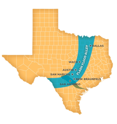
“The famous saying, ‘Turn around, don’t drown’ really does apply here in Flash Flood Alley,” which Graham described as the corridor along I-35 from Dallas to San Antonio.
That’s especially apparent right now as Dallas and surrounding areas are experiencing severe flooding Monday after receiving roughly 10 inches of rain in 12 hours in what one expert called a “once in 1,000 years flood event.”
“Some of the largest rainfall records in North America exist in Central Texas because we have unique topography,” Graham said. “You combine that with the fact we get a lot of moisture from the Gulf of Mexico either from hurricanes or just tropical moisture and usually a cold front from the north and then the two intersect — you get rain right on that boundary.”
The rain doesn’t necessarily mean the drought will let up, Graham added. When the rain comes in quick loads as it does in San Antonio, much of that water runs off rather than sinking into our aquifers, he said.
“We get the same amount of rain as Seattle here — 30 inches per year — but they get theirs a little at a time, whereas we get ours in quick [bouts],” Graham said.
That amount of rainfall is also likely to increase in upcoming decades, according to a report published in October by Texas climatologist John Nielsen-Gammon. Texas will likely alternate between drought and flood in upcoming years, as a result of climate change, according to Nielsen-Gammon’s report.