- Sellers and Rantanen are among the NHL trade deadline winners. Hurricanes and Boeser are some losers
- Hurricane forecasters express concern over NOAA job cuts impact
- FEMA deadline for Hurricane Helene recovery aid extended again
- Tornado drills to take place at schools across North Carolina Friday morning
- Hays County emergency alerts cause confusion during Tuesday's wildfires
Possible tornado touches down on Winona High School football field northeast of Tyler

The Smith County fire marshal said some homes in the area were also damaged.
TYLER, Texas — Officials say a possible tornado damaged several homes and the football field and downed some powerlines in Winona Monday morning amid significant storms.
Smith County Fire Marshal Jay Brooks said a deputy spotted the potential twister around 10:36 a.m. land on the Winona High School football field. He said it caused damage on Hussey Cir. and Johnson Road in Winona.
The Winona ISD police chief said the school was briefly placed on lock down but is back up at its regular schedule, Brooks said just before 11 a.m., according to Smith County.
In a statement, Brooks said four houses have been damaged and there has been damage to power lines and to the high school. The National Weather Service –Shreveport said it had moved out of Smith County.
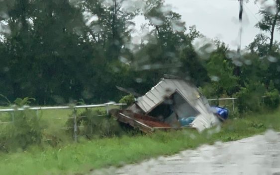
Smith County Precinct 4 Constable Josh Joplin said the reported cyclone took down a fence perimeter of the city water tower, destroyed a modular building, and threw football equipment from the football field into a nearby pasture. He also spotted a portable building lying in the middle of Johnson Road.
Joplin said the storm appeared to have spun up on Johnson Road, traveled across the Winona High School field, over to Hussey Circle and moved north toward Big Sandy. He also noted quite a bit of damage in the Hussey Circle neighborhood.
“This probably is the only one I’ve seen that’s done this amount of damage in a short amount of time,” Joplin said.
Powerlines are also down in the area, Brooks said.
When severe weather strikes, CBS19 will be here to give you minute-by-minute updates.
Rain and storms look to become more scattered going into Monday afternoon. Temperatures will be cool for August in the lower 80s.
Please remember that flooding can be dangerous and it only takes 6″ of rain to sweep you off your feet.
A Flash Flood Warning is in effect for the following counties until 2:15 p.m.:
- Western Camp County
- Southwestern Franklin County
- West Central Gregg County
- Smith County
- Western Upshur County
- Wood County
A Flash Flood Watch has been issued for the following areas:
- Van Zandt County (until Aug. 22, at 12 p.m.)
- Rains County (until Aug. 22, at 12 p.m.)
- Hopkins County (until Aug. 22, at 12 p.m.)
- Wood County (until Aug. 22, at 7 p.m.)
- Rusk County (until Aug. 22, at 7 p.m.)
- Cass County (until Aug. 22, at 7 p.m.)
- Smith County (until Aug. 22, at 7 p.m.)
- Marion County (until Aug. 22, at 7 p.m.)
- Morris County (until Aug. 22, at 7 p.m.)
- Titus County (until Aug. 22, at 7 p.m.)
- Franklin County (until Aug. 22, at 7 p.m.)
- Harrison County (until Aug. 22, at 7 p.m.)
- Upshur County (until Aug. 22, at 7 p.m.)
- Gregg County (until Aug. 22, at 7 p.m.)
- Camp County (until Aug. 22, at 7 p.m.)
- Panola County (until Aug. 22, at 7 p.m.)
The NWS reports flooding has taken over County Road 1513 and County Road 1560, near Alba, in Wood County.
In the city of Van, the following streets are closed due to flooding: Palm between Stadium and Pennsylvania, W. Ohio between N. Birch and County Road 1502, and Walnut between Ohio and Main.
The fire department asked people not drive around the street barricades.
Due to intense flooding, Rains ISD has canceled classes for Monday. Meet the Wildcats, originally scheduled for Monday evening, has also been called off.
The NWS reported a flash flood around 6:20 a.m. in Upshur County saying an area of Holly Rd. in the Gilmer area has washed out and a few trees are down.
Trees have been reported down in the 1200 block of Graham Dr. in Tyler.
Eastern Camp County is also experiencing severe flooding.