- As city leaders consider expanding at-risk zone for wildfire damage, home builders say it could raise costs
- Is your neighborhood at high wildfire risk? | Here's how to check the city's wildfire risk map
- 'Be prepared now': Brad Panovich updates severe weather risk for Sunday
- 'Be prepared now': Brad Panovich updates severe weather risk for Sunday
- As anxiety around wildfires grows, Austin plans to add tens of thousands of acres to risk map
Flash Flood Warning for parts of the Greater Houston area expires
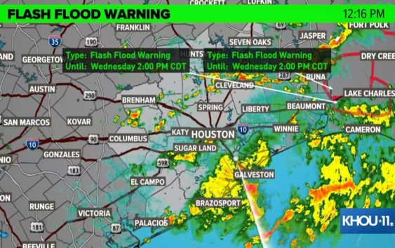
HOUSTON — A Flash Flood Warning for Fort Bend, Brazoria, Wharton and Matagorda counties expired at noon after a group of heavy rains moved the communities southwest and south of the Houston metro area.
A stalled frontal boundary will act as a focal point for developing storms with heavy, tropical downpours over the next two days. On average we should pick up 0.5 to 1.5 inches of rain. We will see the chance for these downpours through the early evening.
There is the threat of these storms producing flooding especially if they track slowly over the same areas and if those areas are vulnerable to such scenarios. Isolated spots could see 2-plus inches… this won’t be for everyone. That will be very isolated.
The setup across our area is supportive of heavy rainfall but the tricky part is pinpointing exactly where that heavy rain may occur. This is why it is important to stay up to date with the latest forecast over the coming days.
Weather Timeline
10 AM Wednesday: Scattered downpours continue to develop across the area.
11 AM Wednesday: Scattered downpours continue.
5 PM Wednesday: Scattered downpours impact the afternoon and evening commute home.
Rain chances drop for the weekend but they are still there.
Check interactive Houston-area radar
Follow the KHOU 11 Weather Team for daily updates: