- As city leaders consider expanding at-risk zone for wildfire damage, home builders say it could raise costs
- Is your neighborhood at high wildfire risk? | Here's how to check the city's wildfire risk map
- 'Be prepared now': Brad Panovich updates severe weather risk for Sunday
- 'Be prepared now': Brad Panovich updates severe weather risk for Sunday
- As anxiety around wildfires grows, Austin plans to add tens of thousands of acres to risk map
Atlantic remains active with two hurricanes, other systems developing
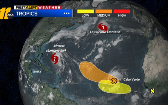
RALEIGH, N.C. (WTVD) — Hurricane Danielle is expected to lose its intensity and be downgraded to a tropical rainstorm soon.
The fourth named storm of the season is moving east-northeastward through the northern Atlantic to the northwest of the Azores. It will come in contact with cooler water and increased wind that will lead to a decrease in intensity.
The system can still bring some rain to western Europe. Minor flooding is possible, but with much of western Europe being recently dry, the rain will be beneficial to most.
There is also Hurricane Earl that should quickly strengthen as it moves to the north and northeast, just east of Bermuda. The island could experience locally strong wind gusts and downpours late in the week.
Earl is a hurricane, and should quickly strengthen as it tracks to the north and then northeast, just to the east of Bermuda. With a close pass, the island could experience strong wind gusts and downpours late in the week.
An area of showers and thunderstorms west of the Cabo Verde islands has a moderate risk for development over the next few days.
Another wave that will move off of Africa late in the week will also need to be watched for development as we head into next week.
Copyright © 2022 WTVD-TV. All Rights Reserved.