- Report: Coastal flooding could threaten 1.4 million homes by midcentury
- Caught on camera | Tornado touches down in Missouri
- Carolina Hurricanes playoff tickets go on sale next week
- Storms kill 6 in the South and Midwest as forecasters warn of catastrophic rains, floods this week
- Weather Impact Alert: Cold front could trigger severe weather in Houston area this weekend | See timeline
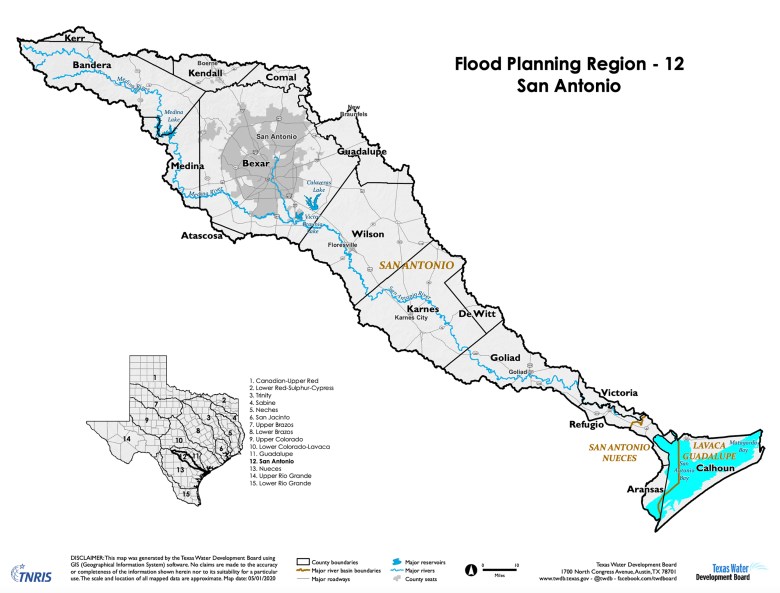
As San Antonians brace for more — and worse — flooding, regional plan targets $1B for flood control

From the deadly flood of 1921 that killed more than 200 people and devastated the West Side of San Antonio to the record-setting flood of 1998 that caused 31 deaths and an estimated $750 million in property damage, San Antonio has seen more than its share of deadly floods — and will likely see more as a result of climate change.
Nor is San Antonio alone. In 2017, Hurricane Harvey caused $125 billion in damage to Houston and surrounding communities, in part due to the catastrophic flooding that followed the Category 4 hurricane’s landfall.
In that storm’s wake, the Texas Legislature approved $1.8 billion to assist in the region’s recovery and better prepare the entire state for future storms. The new legislation called for a statewide flood plan, to be overseen by the Texas Water Development Board. A new “resilience fund” would help pay for flood control projects identified in the plan.
In August, the San Antonio River Authority submitted a draft flood plan to the water board for Region 12, which surrounds the San Antonio River Basin, beginning in Bandera County and extending down to the Texas coastline.
Now, state and local officials are seeking public feedback on the plan, which they will present on Thursday.
Compiling regional data
The regional plan was put together by representatives from the City of San Antonio, Bexar County, the river authority, local utilities and other area water experts. At 672 pages long, the plan offers a comprehensive look at existing flood infrastructure in the area.
It also includes flood risk analyses and recommends specific flood management actions, including roughly $1 billion in needed flood control projects within the region, which includes parts of 16 counties, 49 cities, four river authorities and at least 41 other entities with flood-related authority. More than 2.2 million people live in the 4,422 square mile region, the majority within the San Antonio metropolitan area.
Because of the area’s long history of flooding, several local flood plans already exist. San Antonio, Bexar County and the San Antonio Water System each have plans in place, and have handled local flood mitigation efforts for decades.
Pulling them all together, said Kendall Hayes, government affairs coordinator for the river authority, allows the state to better understand “what existing flood mitigation efforts are out there and what projects need to be done.”
Matt Nelson, deputy executive administrator for the water board’s office of water supply and flood planning, said because of its history of flooding, San Antonio is in better shape than many areas around the state, especially some rural areas.
He encouraged residents interested in the process, or who want to make sure a particular flooding hot spot is included in the plan, to attend the public meeting.
“There are also policy recommendations in the plans for managing floodplains … and that’s a complicated issue,” Nelson said. “It’s good, if the public is interested, to have them look at those things as well.”
Once the water board receives final versions of the regional plans, Nelson said officials will start putting together the state plan, which will include ranking all of the projects within the regional plans. This will help legislators know where state funds should go first, Nelson said.
Prioritizing state funding
“We’ve had some funding for flood projects already,” he said. “But you can’t build a project if you don’t even know what the project is. So [these regional plans are] really about identifying what can be done.”
The water board aims to finalize a statewide plan by 2024. Final regional plans are due to the agency in January of 2023.
The Region 12 draft states that under existing San Antonio-area conditions, roughly 19,100 structures, 753 miles of roadway, 2,733 roadway crossings and almost 80 square miles of agricultural land are at risk of flooding during a 100-year flood event.
Under future conditions — the region is estimated to grow by more than a million people by 2050 — the number of impacted structures is expected to increase by almost 40% to 26,633. The group identified 214 flood mitigation projects totaling over $1 billion.
“History has demonstrated that flood hazards tend to increase over time in populated areas due to projected increases in impervious cover, anticipated sedimentation in flood control structures, as well as other factors that result in increased or altered flood hazards,” the plan states.
These regional flood plans will not be static, said Brian Mast, government affairs manager at the river authority, which acts as the sponsor of the working group that developed the flood plan. Every five years, the group will update the plan based on new Federal Emergency Management Agency flood maps, rain data, construction and other factors, he said.
FEMA flood maps are also revisited every five years. Updated local maps were last released in 2018. FEMA and the San Antonio River Authority are about the begin the process to update area maps again, with public meetings starting next year; new maps should be released in roughly 18 months, a river authority spokeswoman said.
While FEMA flood maps can affect how much homeowners pay for flood insurance, these new regional plans will not have any such impact, she said.
The public hearing on the regional draft plan will be held Thursday, Sept. 15, at 6 p.m. at the San Antonio River Authority’s office at 201 W. Sheridan. The hearing will “receive comments for consideration and incorporation” into the regional flood plan,” according to the river authority’s press release.