- One set of evacuation orders lifted in Caldwell County after wildfire contained
- 'We gutted every building' | Chimney Rock rebuilding after Hurricane Helene
- 'We gutted every building' | Chimney Rock rebuilding after Hurricane Helene
- Debris from Hurricane Helene provides fuel, complicates containment for spring wildfires
- David & Nicole Tepper increase Hurricane Helene relief commitment to $750k
Tropical Storm Fiona forms in Atlantic, sixth named storm of 2022 hurricane season
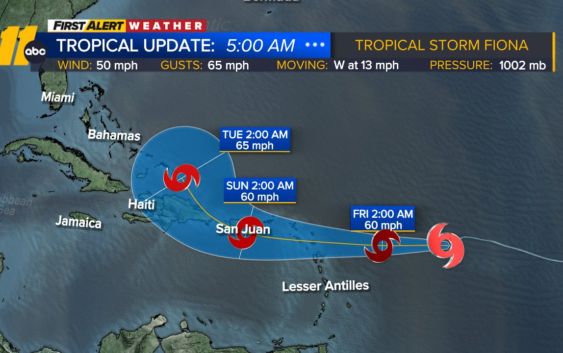
RALEIGH, N.C. (WTVD) — A Tropical Storm Watch has been issued for portions of the northern Leeward Islands as Tropical Storm Fiona moves through the Atlantic.
The center of Fiona is forecast to move through the Leeward Islands late Friday and Friday night, and move near the Virgin Islands and Puerto Rico this weekend. Maximum sustained winds are near 50 mph (85 km/h) with higher gusts.
Forecasts suggests little change in Fiona’s strength during the next few days. The intensity forecast is also complicated as the storm moves near or over portions of the Greater Antilles this weekend and early next week.
Fiona is expected to produce rainfall of 3 to 6 inches with isolated higher amounts across the northern Leeward Islands, the British and U.S. Virgin Islands, Puerto Rico and eastern Hispaniola. These rains may produce flash and urban flooding, along with isolated mudslides in areas of higher terrain.
Surf swells generated by Fiona are expected to begin affecting the northern Leeward Islands by early Friday. These swells could cause life-threatening surf and rip current conditions.
Very different than previous seasons
This hurricane season has been less active than the previous two years. Although 2021 and 2020 were exceptionally active seasons.
Last year, eight named storms had already made U.S. landfall by Sept. 16. In 2020, seven named storms had made U.S. landfall in the same timeframe.
WATCH: First Alert to Hurricane Season
Copyright © 2022 WTVD-TV. All Rights Reserved.