- Charlotte-based marketing agency announces $20,000 Creative Campaign Grant to help communities after Hurricane Helene
- Artists transform hurricane aftermath into hoop-inspired masterpieces at Charlotte exhibit
- NC's cost for Hurricane Helene damage is nearly $60 billion, state says
- State to develop drone program to better respond to disasters like Helene, Florence
- South Carolina residents face deadline to get storm debris out to the curb after Hurricane Helene
Houston Forecast: Storms prompt flood advisory in NE Houston until 6 p.m.

HOUSTON — The National Weather Service has issued a Flood Advisory in northeast Houston until 6 p.m. on Saturday.
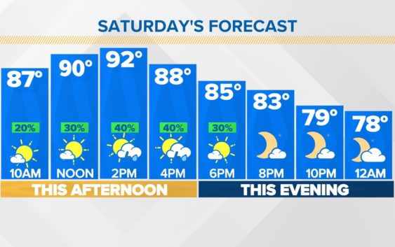
This weekend for the most part looks tranquil. Today is similar to yesterday, we top off in the low 90s but for lots of us it’ll feel like the low triple digits with the humidity. We’ll see cloud cover building this afternoon and 40% of the viewing area is likely to see a passing shower.
For our Sunday we drop that rain chance to 20% and increase the temperatures a bit too, now most of us topping off in the mid 90s.
Notice the afternoon shower chance difference between both days!
We’re going to trade in rain chances and swap them out for s drier and hotter forecast next week despite it being the start of Fall. That means no need to dig into the Fall sweater closet just yet!
Our weather team is also tracking Tropical Storm Fiona in the Atlantic.
Once rain chances taper, the temperatures ramp up a bit. Mid 90s by Monday, continuing through the week will be a few degrees above average for this time of year.
Don’t forget your allergy medication as you head outdoors! Pollen levels continue to run high.
SLIGHT DROUGHT IMPROVEMENTS:
Despite the lack of rain this past week, the drought remains in check. Little improvement but at least no significant chances for the worse! And it’s worth highlighting, the entire state has nearly obliterated the Exceptional Drought Category.
Across the area, several of our counties (listed above) are no longer in ANY drought category.
All of our counties are also out of the worst categories — exceptional and extreme. Austin and Colorado counties remain largely under a Severe Drought, so those will be areas we continue to monitor.
Follow the KHOU 11 Weather Team for the latest updates on the forecast: