- NC burn ban lifted statewide as rain improves wildfire conditions
- Western NC wildfire risk will 'get worse, not better' Ag Commissioner says, pressing lawmakers for help
- Watering trees is a must to protect them from severe weather and drought
- At least 4 dead, hundreds rescued after deadly floods ravage South Texas
- Today on Texas Standard: Deadly floods swamp South Texas, shatter records
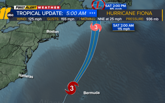
Category 3 Hurricane Fiona may bring 10-12 foot swell to NC Outer Banks

RALEIGH, N.C. (WTVD) — Fiona remains a powerful Category 3 hurricane over the western Atlantic and is expected to pick up speed and retain major hurricane-force wind intensity as it continues to the northeast Friday.
The system will bring large swells to the North Carolina coast and Outer Banks, some areas may see waves as high as 10-12 feet. The rip current risk will also remain high until Saturday. The swell increase should start subsiding later on Friday.
The storm is bringing heavy rain and damaging winds to Bermuda now as it passes to the west, then will pick up speed and head northward into Atlantic Canada this weekend.
Despite losing some wind intensity, Fiona is still expected to bring destructive winds, flooding rain and coastal flooding to Canada, which can lead to widespread power outages and damage to structures. This will be one of the strongest storms ever to hit the Atlantic side of Canada.
Invest 98L is near the coast of Venezuela and is still disorganized due to strong shear and land interaction. However, this is likely to end up in an area of very warm water and low shear over the northwestern Caribbean this weekend, and so still has a high chance of development to a hurricane before passing into the Gulf of Mexico early next week.
Depending on the exact track and intensity, there may be impacts to parts of Central America as well as Jamaica, the Caymans and Cuba before impacting parts of the U.S. Gulf coast.
Copyright © 2022 WTVD-TV. All Rights Reserved.