- Firefighters make significant progress on western NC wildfires overnight
- Star-studded FireAid benefit concert for LA wildfire relief kicks off Thursday night. Here's how to watch
- FireAid, a benefit for LA wildfire relief, is almost here. Here's how to watch and donate
- Crews continue to make progress on wildfires in McDowell County
- McDowell County wildfire grows to 250 acres, evacuation orders remain
How Hurricane Ian will impact North Carolina and South Carolina

With Hurricane Ian bearing down on Florida, many Carolinians are wondering what its impact will be up the coast once it makes landfall.
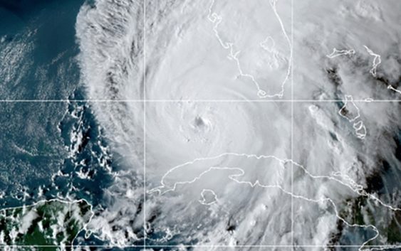
CHARLOTTE, N.C. — The U.S. National Hurricane Center said Hurricane Ian’s most damaging winds are hitting Florida’s southwest coast as the storm approaches landfall.
The hurricane’s center of circulation neared Florida on Wednesday after rapidly intensifying overnight, gaining top winds of 155 mph by 8 a.m. That puts Ian just shy of devastating Category 5 hurricane status.
Ian is pushing a storm surge that could cause catastrophic damage along the state’s heavily populated Gulf Coast. Forecasters say the Fort Myers region is at the highest risk of a surge that could reach 18 feet.
At least 2.5 million people were ordered to evacuate.
As that storm surge moves up the East Coast, it’s expected to impact Savannah and even into Charleston and most of coastal South Carolina, according to WCNC Charlotte Chief Meteorologist Brad Panovich.
Brad expects to see storm surge in that area upwards of 3 feet. There will be beach erosion all the way up to the Wilmington area in North Carolina, and throughout Myrtle Beach, Charleston, and Hilton Head in South Carolina.
Overall, Ian is going to become a big rain threat as it moves up to the western Carolinas. Winds will also be an issue, most likely starting Thursday.
Some showers may break out ahead of the storm, but most people in the Charlotte area will wake up to some light rain Friday around 4 a.m. Rain will increase into Friday afternoon and Saturday. Heavy rain is expected through Saturday with some rain lingering into Sunday.
Brad Panovich forecasts the flash-flood risk will ramp up on Saturday and Sunday.
In western Carolinas, Ian will mostly be a flash flood and wind risk. Excessive rainfall will be to the south of Charlotte on Friday. On Saturday, that risk shifts mainly to the mountains. There’s currently a 40% chance of flash flooding in the range of 4 to 7 inches of rain on Sunday in the mountains and even into the foothills. In the Charlotte area, residents should expect about 3 to 5 inches of rain.
The Associated Press contributed to this report.