- Texas’ biggest wildfire started a year ago. How does the Panhandle look now?
- To her, Hurricane Helene debris isn’t trash. It is full of memories — and she’s returning them
- Bills introduced a year after state’s largest blaze seek to limit wildfires
- A year after Texas’ largest wildfire, Panhandle residents tugged between hope and anxiety
- Another $500M for Hurricane Helene relief in North Carolina passes key hurdle
Hurricane warning issued for entire SC coast, tropical storm warning for the Midlands

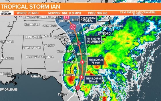
After moving across Florida, Tropical Storm Ian is expected to move up to South Carolina, bringing with it heavy rain and strong winds.
COLUMBIA, S.C. — Tropical Storm Ian has moved off the Florida coast after causing extensive damage in Florida when it was a powerful Category 4 storm. Now, it’s set to become a weak hurricane again where it will come into the South Carolina Friday, bringing with it heavy rainfall and strong winds on Friday.
As of the 11 a.m. advisory from the National Hurricane Center, Ian had maximum sustained winds of 70 miles an hour and was moving to the north-northeast at 9 miles an hour. When its winds increase to 74 miles an hour or greater, it will be a Category 1 hurricane.
Watches/Warnings for South Carolina:
A hurricane warning is in effect for the entire South Carolina coast.
A tropical storm warning has now been issued for the entire Midlands. That list of counties includes Richland, Lexington, Sumter, Orangeburg, Saluda, Lee, Clarendon, Fairfield, Kershaw, Calhoun, and Newberry. That means winds between 25-35 miles an hour with gusts up to 45 miles an hour.
Midlands Impacts:
Heavy rainfall, flash flooding will be the greatest threat as the rain moves in overnight Thursday and into Friday. Widespread rainfall totals of 3 to 6 inches is forecast. Some isolated areas will probably get more than that. According to the Weather Prediction Center, the southeastern half of the Midlands is in a moderate risk for excessive rainfall.
Gusty winds are expected as Ian nears the coast Friday. While tropical-storm-force winds are not expected, tropical-storm-force gusts, winds above 50 mph will be possible. The strongest winds are likely on the east to northeastern part of what is left of the storm’s circulation center.
These winds are likely to pass north of the area by Saturday afternoon, with generally decreasing southerly winds behind the system.
Severe weather, along with isolated tornadoes are possible, but given the current track, the highest threat will likely be along the coast. If the track were to shift, our threat could increase.
Our in-house forecast model takes the rain out of the area later in the day on Friday, but the global models keep the rain chances around through the weekend. As of now, we will keep a chance for rain on Saturday and Sunday in the forecast, but this could change depending on how fast Ian moves out of the area.
Midlands Timeline:
Thursday Evening:
Some rain is possible, especially in the eastern half of the state. Winds will continue to increase to about 15 to 20 mph.
Early Friday morning:
Heavy rain starts to move into parts of the state, including parts of the Midlands. Winds will be picking up to about 15-25 mph with some stronger gusts.
Friday morning:
Heavy rainfall continues across the area. Winds will be gusty, out of the northeast at 15-25 mph with some stronger gusts. With the heavy rain and winds, some power outages will be possible.
Friday afternoon:
Heavy rainfall continues for a large portion of the state, but the rain starts to taper off along the coastal region of South Carolina. Winds will still be strong at times, out of the northeast at 20-30 mph with gusts stronger around 40 to 50 mph.
Friday evenig:
Our in-house forecast model starts to bring the rain to an end. The global models keep the rain around through at least Saturday.