- How to watch the FireAid benefit concert for LA wildfire relief
- FireAid, a benefit for LA wildfire relief, is almost here. Here’s how to watch and donate
- Burgaw Mayor to speak with Western North Carolina officials about flooding
- Firefighters report significant progress on McDowell County wildfires
- North Carolina officials make urgent request to lawmakers on Helene and other hurricanes
Tropical storm warning issued for Triangle, some school systems begin announcing closures
RALEIGH, N.C. — North Carolina is bracing for impacts from Tropical Storm Ian as the storm’s remnants are expected to enter the state Thursday night.
Thursday, Sept. 29
2 p.m. Tropical Storm Ian update
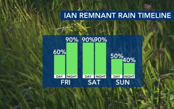
Eastern counties are under a Level 2 risk for severe storms for Friday, while Wake County is now included in a Level 1 risk. The Triangle is under a Tropical Storm Warning, and schools systems are starting to report closings or delays for Friday — including Orange County, Edgecombe County and Lee County schools, among several others. Chatham County schools are offering a remote learning day.
11 a.m. Tropical Storm Ian update
Parts of central N.C. are under a tropical storm warning and a flood watch until Saturday morning. As of the 11 a.m. advisory, Ian is still a tropical storm with winds of 70 mph, a bit stronger than this morning. Ian expected to strengthen back into a Category 1 hurricane as it heads toward the South Carolina coast, where landfall is expected near Charleston on Friday.
Local impacts from Ian begin Thursday night and continue through Saturday morning. There is a Level 1 severe risk in place Friday for areas east of the Triangle, and most everyone will see heavy rain.
River flooding, isolated tornadoes and wind gusts up to 50 mph are likely,
The storm’s faster track will lead to North Carolinians seeing the heaviest rain and strongest winds throughout the day Friday. Models call for 1 to 4 inches of rain in the Triangle and maximum wind gusts between 40 to 50 miles per hour. Flash flooding is our greatest threat and an isolated tornado can’t be ruled out.

Up to 5 inches of rain will be possible in coastal communities, with isolated totals reaching 10 inches.
The mountains of North Carolina near the Blue Ridge Parkway are also expected to experience heavy rain with the chance for landslides and up to seven inches of rain.
Lee County Schools announced a remote learning day on Friday, and Moore closed schools.
8 a.m. Tropical Storm Ian update
Ian remained a tropical storm with 65 mph winds in the 8 a.m. advisory. Ian’s center of circulation was near Orlando, and the storm will be back over the Atlantic Ocean late Thursday morning. It could strengthen some over water but is not expected to regain hurricane strength, WRAL meteorologist Elizabeth Gardner explained.

Ian could make landfall along South Carolina’s coast near Charleston, Gardner said. N.C. will feel most impacts, including heavy rain and wind gusts up to 40 to 50 mph, all day Friday rather than on Saturday. The heaviest rain will be Friday, although rain could begin Thursday night. Isolated showers will continue Saturday, Sunday and Monday.
There is a Level 1 risk for severe weather on Friday southeast of the Triangle. The best chance for isolated tornadoes will be east of our viewing area, but there will be a low chance for tornadoes in central N.C. Highs on Friday will be in the low to mid 60s, returning to the low 70s for the weekend.
Before the 5 a.m. advisory, Ian was a Category 1 storm moving north at 10 mph with maximum sustained winds of 75 mph.
Devastating damage in Florida
Hurricane Ian has left a path of destruction in southwest Florida, trapping people in flooded homes, damaging the roof of a hospital intensive care unit and knocking out power to 2 million people before aiming for the Atlantic Coast.
In Port Charlotte, along Florida’s Gulf Coast, the storm surge flooded a lower-level emergency room in a hospital even as fierce winds ripped away part of the roof from its intensive care unit, according to a doctor who works there.
Wednesday, Sept. 28
Hurricane Ian moved quickly once it reached Florida, staying a major Cat. 3 hurricane hours before weakening. Hurricane warnings were posted the eastern and central coast of Florida, and a hurricane watch was issued for parts of the Georgia and South Carolina coast.
Ian will weaken after making landfall Wednesday afternoon in southwestern Florida. The track takes the storm across Orlando as a tropical storm Thursday morning, out into the Atlantic ocean and toward North Carolina and South Carolina on Friday.
A large part of the North Carolina coastline is under a tropical storm warning or tropical storm watch. At 5 p.m., a tropical storm warning was extended to include Surf City, North Carolina. A tropical storm watch was issued from Surf City to Cape Lookout.
Rain could begin as early as Friday morning in North Carolina. The storm’s faster track will lead to North Carolinians seeing the heaviest rain and strongest winds throughout the day Friday, according to WRAL meteorologist Kat Campbell. Most models call for 1 to 4 inches of rain in the Triangle and maximum wind gusts between 40 to 50 miles per hour. Flash flooding is our greatest threat and an isolated tornado can’t be ruled out.
Up to five inches of rain will be possible in coastal communities, with isolated totals reaching 10 inches.
The mountains of North Carolina near the Blue Ridge Parkway are also expected to experience heavy rain with the chance for landslides and up to seven inches of rain.

Showers and thunderstorms will linger into Sunday and possibly Monday.
Gov. Roy Cooper issues state of emergency
As Hurricane Ian has made landfall in Florida, North Carolina Gov. Roy Cooper issued a state of emergency on Wednesday in advance of potentially severe weather.
The State Emergency Response Team is moving equipment around North Carolina to prepare for possible use depending on how Ian evolves as it moves north from Florida.
Virginia and South Carolina officials have also declared a state of emergency.
NC State, UNC football to play Saturday games as scheduled as Hurricane Ian hits Florida
Hurricane Ian made landfall Wednesday morning on the west coast of Florida. It has forced changes to this weekend’s college football schedule across the Southeast.
No moves have been made to ACC games that could be impacted by the storm. No. 10 NC State is scheduled to play at No. 5 Clemson on Saturday night, No. 22 Wake Forest visits No. 23 Florida State on Saturday afternoon and North Carolina hosts Virginia Tech on Saturday afternoon.
Catastrophic damage expected in Florida
Hurricane Ian made landfall as a Category 4 storm and had maximum sustained winds of 145 MPH as of the 4 p.m. advisory on Wednesday. Ian made landfall near Cayo Costa, Florida, at 3:05 p.m. and is described as ‘extremely dangerous’ by the National Hurricane Center. It was downgraded to a category 1 storm with 90 MPH winds around 11 p.m., but is still powerful and has caused major damage throughout Florida.
Radar-estimated rain totals are already over 10 inches in parts of Florida on Wednesday night. As of 10 p.m., the storm was 95 miles south/southwest of Orlando.
Ian is tied for the fourth-strongest hurricane to hit Florida and was moving inland around Punta Gorda around 4 p.m.
The wind is violent and the storm surge has been devastating in some areas, going up to the roof line of homes in a few instances. Naples and Ft. Myers set records for their storm surge totals.
On Wednesday afternoon, there were already an estimated 2 million power outages in Florida.
Florida’s southwestern coastal communities, including Naples and Fort Myers, will be most impacted, WRAL meteorologist Elizabeth Gardner said.
The impact of a Category 4 storm hitting the coast will be devastating. “Storm surge will be immense,” Gardner said, up to 12 to 16 feet along Florida’s west coast, which could get up to 24 inches of rainfall.