- Fake job seekers are flooding the market, thanks to AI
- One set of evacuation orders lifted in Caldwell County after wildfire contained
- 'We gutted every building' | Chimney Rock rebuilding after Hurricane Helene
- 'We gutted every building' | Chimney Rock rebuilding after Hurricane Helene
- Debris from Hurricane Helene provides fuel, complicates containment for spring wildfires
Hurricane Ian downgraded to post-tropical cyclone, will still dump rain on Charlotte through Friday night
Ian made landfall in Georgetown, South Carolina, battering the coast with 85 mph winds, torrential rain and dangerous storm surge.
CHARLOTTE, N.C. — The eye of Hurricane Ian made landfall on the South Carolina coast near Georgetown just after 2 p.m. Friday, the National Hurricane Center confirmed, slamming the Carolinas with 85 mph winds and gusts around 100 mph.
By 5 p.m., Ian was downgraded to a post-tropical cyclone. According to the National Hurricane Center, Ian still has a dangerous storm surge, flash flooding potential and and a high wind threat.
WCNC Charlotte chief meteorologist Brad Panovich said heavy rain associated with Ian will continue to drench the Charlotte area through 11 p.m. with the worst of the storm expected to last until around 7 p.m. which caused a messy commute
The Charlotte area has seen wind gusts up to 35 mph Friday, with the bulk of the storm coming Friday afternoon and evening. Panovich said the Charlotte metro is at risk of seeing the highest winds and heaviest rain any time after 3 p.m.
According to FlightAware, hundreds of flights at Charlotte Douglas were canceled and dozens were delayed Friday due to persistent rain and wind from Ian’s outer bands. The first rain bands from Ian moved into the Charlotte area by 7 a.m. Friday.
Thousands of Duke Energy customers were without power in the Charlotte area as of Friday afternoon, according to Duke Energy’s outage map. WCNC Charlotte will continue to monitor outages and when customers can expect power to be restored.
Friday in the Carolinas
Panovich said he is growing more concerned about the potential for flash flooding from Ian’s heavy rain and winds on the northwest side of the storm. This means the worst weather is expected in the Charlotte metro from around 4 p.m. until 10 p.m. Friday.
“Why is this a big deal? That’s where we have flash flood warnings,” Panovich said.
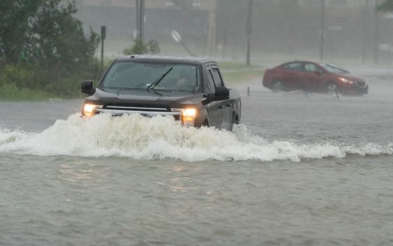
Charleston was already starting to flood early Friday, with WCNC Charlotte’s Vanessa Ruffes reporting knee-high floodwaters near the Battery at Charleston Harbor. Low-lying areas were underwater, with officials encouraging people to seek higher ground due to the flooding risk.
Panovich said Charleston reported wind gusts as high as 56 mph as Ian moves closer to landfall.
Conditions deteriorated quickly along the South Carolina coast Friday morning.
A Tropical Storm Warning is in effect for Anson, Cabarrus, Catawba, Chester, Chesterfield, Dorchester, Gaston, Iredell, Lancaster, Lincoln, Mecklenburg, Richmond, Rowan, Stanly, Union and York counties in the Charlotte area ahead of Ian. The warning is in effect until around 7:15 p.m. but conditions might change.
Panovich said the rain feels more like a nor’easter than a tropical system, with Charlotte’s temperatures in the low-to-mid 50s Friday. That’s good news for the severe weather threat, which is low in the metro.
“The storm is not going to get much stronger. If anything, it looks like a hybrid system,” Panovich said. “It’s probably more of a subtropical storm, which doesn’t really matter for impacts, but it does mean that it’s not going to get that much stronger because we don’t have thunderstorms near the center.”
Our biggest impacts locally will be gusty winds and heavy rain, mainly Friday night through early Saturday morning.
Friday is a Weather Aware Day. Any time a person sees the Weather Aware label on the forecast or on social media, they know it’s about their personal safety, their family’s safety and protecting their property.
Beyond the typical severe weather, there are dangerous heat waves, record-breaking cold snaps or even hazardous winds that could impact people’s safety. Those instances would cause WCNC Charlotte’s Weather Team to tell everyone they should be Weather Aware.
Saturday in the Carolinas
The storm will move through the Piedmont fairly quickly Friday night, which is good news for any flooding. The mountains and foothills of North Carolina will be at a greater risk of flooding as the rain lingers Saturday morning. Panovich said the flash flood risk is significant, especially in the mountains where the runoff will be moving quickly.
Panovich said there could be flash flooding in North Carolina cities across the area, including Charlotte, Concord, Gastonia, Hickory and Huntersville as Ian drenches the Carolinas. Fortunately, it’s moving quickly for most of the Charlotte metro.
“Saturday afternoon is looking much better,” Panovich said. “It’s probably going to be windy with some isolated showers but not too bad.”
Ian rainfall projections for the Carolinas
North Carolina mountains: 3 – 6 inches
Charlotte metro: 2 – 4 inches
Winds will gust as high as 60 mph in the North Carolina mountains. The strongest wind gusts in Charlotte are expected to be between 40 – 45 mph.
Along the coast, storm surge totals could reach 5 feet in places like Charleston, South Carolina.
What you can expect from WCNC Charlotte?
Brad Panovich and the WCNC Charlotte weather team will provide updates on Ian throughout the weekend.
Receive severe weather alerts straight to your phone by downloading the WCNC Charlotte app, where you can also send the team photos and videos of the storm as it is safe to do so.
Brad and the team will have expanded, live-streaming coverage of the storm, which you can watch for free on the WCNC Charlotte phone app, the WCNC+ apps for Roku and Amazon Fire, YouTube, and on WCNC.com.