- 'Be prepared now': Brad Panovich updates severe weather risk for Sunday
- 'Be prepared now': Brad Panovich updates severe weather risk for Sunday
- As anxiety around wildfires grows, Austin plans to add tens of thousands of acres to risk map
- 'Not enough firefighters' | Rural fire departments in Central Texas get boost to help them fight wildfires
- National Hurricane Center announces storm names, procedural changes ahead of 2025 season
Timeline: Tracking severe weather possible for Friday night into Saturday

All modes of severe weather are possible.
AUSTIN, Texas — While we have been mainly dry through most of the week, that is expected to change as we head into Friday night and Saturday.
Many high schools have moved their previously-scheduled Friday night games to Thursday night and, based on latest forecasts, that appears to be a wise decision.
Timing
Friday looks to start off with a few isolated showers, which could cause some issues for the morning commute. Temperatures at this point look to be anywhere in the low to mid-70s due to a strong southerly flow.
By the afternoon, we expect a sunny, dry lull with highs in the upper 80s. However, there is a bit of a deceptive factor associated with this.
With the added moisture in the atmosphere, Friday won’t be a day that you’d want the sun out, as the heating of the day could cause that line of storms to strengthen as it approaches the KVUE viewing area.
By later Friday evening, we expect things to pop off somewhat as the frontal boundary approaches. Currently, we expect this line to approach the KVUE viewing area by around 8 p.m., but as the event gets closer, we’ll iron this out further.
We do expect that line of storms to be out at least by sunrise Saturday morning. However, models have hinted at faster movement of the potential squall line, and some models have this storm out of the KVUE viewing area even before midnight.
Threats
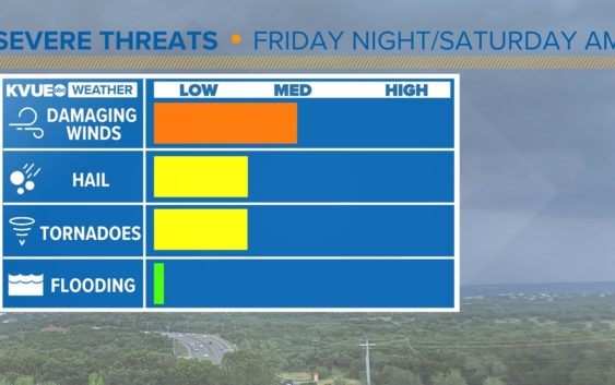
With the added instability ahead of the front and its strength as it slides through Friday night, we’re looking at mainly a damaging wind threat, although large hail and isolated tornadoes cannot be ruled out by any means.
As a result, nearly the entire KVUE viewing area is under a 2 out of 5, or “slight,” risk for severe weather.
Stick with the KVUE Storm Team for the latest on this developing situation.
In the meantime, the 7-Day forecast is below.
PEOPLE ARE ALSO READING: