- 'A little emotional': Hurricanes equipment manager got seconds in goal, memory to last a lifetime
- WMO retires three hurricane names after devastating 2024 season
- Beryl removed from future hurricane naming lists
- Hurricane names Helene, Milton and Beryl are now retired
- Hurricane Helene's name retired after deadly 2024 impact on US
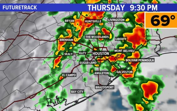
Houston weather: Street ponding, flooding possible this evening

Showers turn to widespread rain after 5 p.m., with the worst occurring between 8 p.m. and 1 a.m. Friday.
HOUSTON — Isolated showers will be possible throughout the day, however, widespread activity will hold off until later this evening.
Another day of gulf moisture pumping in has brought our highs to the mid and upper 70s. Humidity has also significantly increased. With tonight’s front all that fuel will be used for showers and thundershowers.
Showers turn to widespread rain after 5 p.m., with the worst occurring between 8 p.m. and 1 a.m. Friday.
Localized street flooding is possible, although widespread issues are not expected.
The areas that have the highest probability of seeing heavy rain street impacts include our northern cities and counties and along the coast. Models are showing these spots could receive an excess of 2″ of rain, which may not be manageable for poor drainage areas.
The bulk of the rain will depart the area well before sunrise Friday. However, a few showers may linger, especially at the coast during the day before nice weather arrives for the weekend.
In addition to that, look out for dense fog Friday morning from the leftover moisture.
By Friday evening its smooth sailing. The forecast for New Year’s celebrations continues to look good across the area. Temperatures are expected to be near 60 at midnight under mainly clear skies.
Follow the KHOU 11 Weather Team for the latest updates on the forecast: