California hit by more storms, braces for potential floods

SAN FRANCISCO — California was hit with more turbulent weather Sunday as thunderstorms, snow and damaging winds swept into the northern part the state, preceding another series of incoming storms and raising the potential for road flooding, rising rivers and mudslides on soils already saturated after days of rain.
The National Weather Service warned of a “relentless parade of atmospheric rivers” — storms that are long plumes of moisture stretching out into the Pacific capable of dropping staggering amounts of rain and snow.
In the state capital, more than 215,000 customers were without electricity Sunday in the city of about 525,000 residents after gusts topping 60 mph (97 kph) knocked trees into power lines, according to the Sacramento Municipal Utility District.
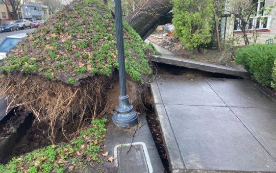
Joey Kleemann was listening to the winds howling shortly after midnight, wondering whether she should move her car, when she heard a “gigantic, thumping, crashing sound” as a massive tree fell onto the Sacramento home where she’s lived for 25 years.
The gusts were strong enough to rip the tree up from its roots, pulling the concrete sidewalk up with it.
Cracks in the roof meant rain streamed into her dining area throughout the night. She’s hoping to get a tarp over the damaged area in anticipation of more showers.
“I just had a feeling with the winds. They were scary winds,” she said. “Mostly I focused on: it could be so much worse.”
The weather service’s Sacramento office said the region should brace for an even more powerful storm system to move in late Sunday and early Monday.
“Widespread power outages, downed trees and difficult driving conditions will be possible,” the office said on Twitter.
Evacuation warnings were in place for about 13,000 residents of a flood-prone area of Sonoma County north of San Francisco, where the swollen Russian River was expected to overspill its banks in the coming days.
The state Department of Transportation warned motorists to stay off mountain roads after closing a stretch of U.S. 395 in Mono County due to heavy snow, ice and whiteout conditions along the Eastern Sierra.
“With the severe nature of this storm, Caltrans is asking all drivers to limit nonessential travel until the peak of the storm has passed,” the department said in a statement.
The wet weather comes after days of rain in California from Pacific storms that last week knocked out power to thousands, flooded streets, battered the coastline and caused at least six deaths.
The first of the newest, heavier storms prompted the weather service to issue a flood watch for a large swath of Northern and Central California with 6 to 12 inches (15 to 30 centimeters) of rain expected through Wednesday in the already saturated Sacramento-area foothills.
In the Los Angeles area, scattered rain fell during the weekend while stormy conditions were expected to return Monday, with the potential for up to 8 inches (20 cm) of rain in foothill areas. High surf was expected through Tuesday, with large waves on west-facing beaches.
Since Dec. 26, San Francisco received more than 10 inches (25 centimeters) of rain, while Mammoth Mountain, a popular ski area in the Eastern Sierra, received nearly 10 feet (3 meters) of snow, the National Weather Service reported.
The storms won’t be enough to officially end California’s ongoing drought — but they have helped.
State climatologist Michael Anderson told a news briefing late Saturday that officials were closely monitoring Monday’s incoming storm and another behind it and were keeping an eye on three other systems farther out in the Pacific.