- Here’s how Austin-area leaders are preparing for wildfire threats this summer
- Harris County sues Trump administration, cites threat to hurricane season preparedness
- Prescribed burn in Morrow Mountain aims to prevent future wildfires
- Prescribed burns aim to prevent wildfires in Stanly County
- Prepare for hurricane season with the Town of Leland Hurricane Expo
Tornado watch issued until 10 p.m.

Strong to severe storms are possible for the greater Charlotte area Thursday which will be followed by snow in the mountains.
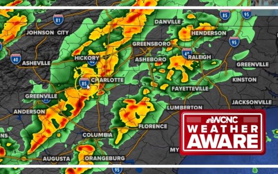
CHARLOTTE, N.C. — The National Weather Service has issued a tornado watch until 10 p.m. for most of the Charlotte metro area. A Tornado Watch means tornadoes are possible as a strong line of thunderstorms moves through the Carolinas.
If any storm produces a tornado, the National Weather Service will follow up with a tornado warning, if needed.
A strong cold front will bring a line of thunderstorms to the Carolinas Thursday with the possibility of severe weather in the Charlotte area.
Chief meteorologist Brad Panovich says Charlotte is right on the borderline between nasty weather and regular storms associated with this type of weather pattern.
The biggest threats during Thursday’s storms will be heavy rain and damaging winds. There is also a risk of spin-up tornadoes along the leading edge of the front as it moves over the Carolinas Thursday afternoon.
Behind the front is something totally different: The North Carolina mountains are expecting snow with heavy snowfall possible from Thursday night through Friday. Higher elevations could see up to 5 inches, while areas around Blowing Rock and Boone are expecting somewhere around 2 inches of snow. Charlotte won’t see any snow, but we’re expecting a much cooler weekend with chilly temperatures.
Live interactive radar
Thursday: Thunderstorms
Thursday will be a warm and breezy day, and this is all a precursor for the cold front that is arriving later in the day.
The day will start off cloudy but will stay mostly dry outside of a passing rain shower. By the afternoon, storms are possible and some severe thunderstorm warnings could pop up in the late afternoon and early evening.
“We’re kind of on that edge,” Panovich said of the severe weather risk. “The Upstate of South Carolina is definitely an area that is more at risk than east of I-77. West of I-77 into the Upstate of South Carolina is definitely an area of greater concern.”
Threats
- Damaging wind gusts. Winds mainly gusting 40 – 60 mph
- Isolated tornado possible
- Heavy rain during a short time period
Timing
Panovich says there will be some clouds and drizzle over the Charlotte area by early afternoon. Those clouds and showers could actually stabilize things and reduce the risk of severe weather in some areas.
“About 4 o’clock, some isolated cells will break out ahead of the line. We’ve got to keep an eye on these,” Panovich said. “If these do develop south of the warm front or even along the front, those would have the potential to rotate.”
The main line will move through Charlotte around 6-8 p.m. Panovich says heavy rain and strong winds are likely in the Charlotte metro through 9 p.m. with those gusty winds being the biggest threat Thursday.
Snow Forecast
Behind this front, colder air will filter in, which will lead to snow in the high country. Charlotte and surrounding areas will be precipitation free by the time it is cold enough for snow.
Snow will start late Thursday night and be on and off through Friday, ending by late evening, which is great news for skiers and snowboarders. A second round will add more accumulation Friday night into Saturday morning!
Snow Totals
Totals will peak around 4 – 6 inches for areas 5,000 ft and above, including Beech Mountain, Sugar Mountain, and Grandfather Mountain.
1 – 3 inches are possible for areas like Banner Elk and Gingercake Mountain. Blowing Rock and Boone are closer to 1 – 2 inches with lower totals for places like Jefferson and Valle Crucis.