- NC Gov. Stein pledges continued Hurricane Helene recovery support in 100-day address
- Austin adopts new map that greatly expands area at risk of wildfire
- CenterPoint Energy accelerates infrastructure improvements ahead of hurricane season
- Carolina Hurricanes playoff tickets go on sale Thursday
- Ask the Meteorologist: Why do tornadoes target Tornado Alley, Dixie Alley?
LIVE UPDATES: Severe weather could spawn tornadoes, lead to flooding in Houston area

Some areas could see heavy rainfall amounts of 1 to 3 inches with isolated areas getting more than 6 inches possibly.
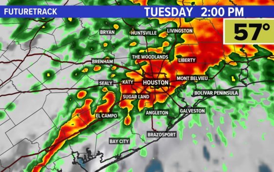
HOUSTON — Severe weather is expected today with a chance for strong winds, tornadoes, and potential flooding across the Houston area.
Stay weather smart today. Get the KHOU 11 app to get alerts when severe weather watches and warnings are issued for your part of town. And we’ll be live throughout the day on KHOU 11+, which you can get for free on Roku and Fire TV.
What you need to know
- The strongest of the storms should be in the Houston area between 10 a.m. and 5 p.m.
- In the early afternoon, a squall line will develop along the incoming cold front, which could produce damaging winds and isolated tornadoes, especially for those south of I-10.
- The area could see wind gusts from 30 to 50 mph, according to the National Weather Service.
- With the strong wind gusts, loose items could get blown around, high-profile vehicles could be impacted and residents are encouraged to secure outdoor items.
- Some areas could see heavy rainfall amounts of 1 to 3 inches with isolated areas possibly getting more than 6 inches.
Houston radar
What is a tornado warning?
A Tornado Warning is issued by the local NOAA Office meteorologists who monitor the weather in the area. NOAA said they issue a warning when a tornado has been reported by spotters or indicated by radar and there is a serious threat to life and property in its path. During a tornado warning, you should act right away to find safe shelter.
What is a tornado watch?
During a Tornado Watch, tornadoes are possible in and around the watch area, according to NOAA. This means it is a good time to review your emergency plans. It is important to act quickly if a tornado warning is issued and if you spot one coming.
What to do during a tornado
When a tornado warning is issued, it is important to act quickly, according to NOAA.
If you are home, be sure to go to a safe room or an interior room away from windows, which could get blown out.
If you are in a workplace or school, be sure to follow your tornado drill instructions and head to your shelter location. Again, stay away from windows. NOAA also advises against going into large open rooms like a cafeteria or gymnasium.
If you are outside, seek shelter inside a sturdy building. NOAA said to avoid sheds and storage facilities.
If you are in a vehicle, you are advised to drive to a sturdy shelter. If you are not able to get to a shelter, get down into your car or abandon it and head to a low-lying area like a ditch.
What are the signs of a tornado?
Some tornadoes form without any warning, so it is important to know what to look for. According to NOAA, these are the signs to look for:
- Strong, persistent rotation in the cloud base.
- Whirling dust or debris on the ground under a cloud base — tornadoes sometimes have no funnel!
- Hail or heavy rain followed by either dead calm or a fast, intense wind shift. Many tornadoes are wrapped in heavy precipitation and can’t be seen.
- Day or night – Loud, continuous roar or rumble, which doesn’t fade in a few seconds like thunder.
- Night – Small, bright, blue-green to white flashes at ground level near a thunderstorm (as opposed to silvery lightning up in the clouds). These mean power lines are being snapped by very strong wind, possibly a tornado.
- Night – Persistent lowering from the cloud base, illuminated or silhouetted by lightning — especially if it is visually in ground contact or there is a blue-green-white power flash underneath.
Latest updates:
Tuesday, Jan. 24
8:55 AM: The National Weather Service has issued a special weather statement for El Campo, Ganado and Louis until 9:30 a.m.
7:55 AM: Early morning showers have already made for slick roadways during the rush commute.
Monday, Jan. 23
8:30 PM: Houston ISD said it is monitoring the weather conditions, but nothing announcements have been made yet.