- Artists transform hurricane aftermath into hoop-inspired masterpieces at Charlotte exhibit
- NC's cost for Hurricane Helene damage is nearly $60 billion, state says
- State to develop drone program to better respond to disasters like Helene, Florence
- South Carolina residents face deadline to get storm debris out to the curb after Hurricane Helene
- SCDOT to pick up Hurricane Helene debris for a final day in South Carolina
Tornadoes touch down in Oklahoma, Kansas as massive winter storm moves east

At least nine tornadoes were reported in Kansas and Oklahoma on Sunday night as a massive winter storm moves east across the U.S.
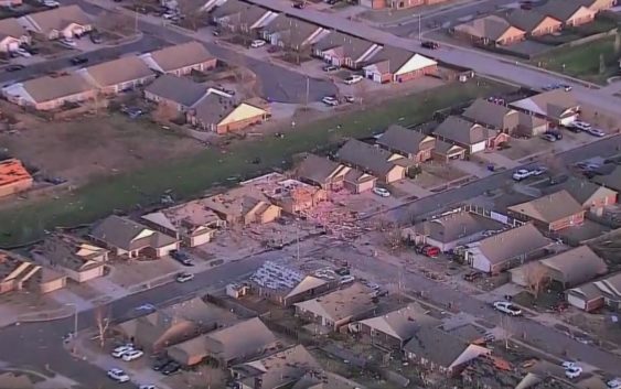
One tornado destroyed a home, toppled trees and knocked over power lines in Liberal, Kansas, near the state line with Oklahoma, according to local authorities.
At least 12 people were injured due to the severe weather in Oklahoma’s third-largest city, Norman, located about 20 miles south of the state’s capital. None of the injuries were critical and there were no reported fatalities, according to the city.
Drones are helping assess damage on Monday, Norman Police Chief Kevin Foster said.
Some roads have been shut down and two Norman elementary schools are closed, Foster said.
Wind gusts over 70 mph and hail measuring 1 inch in diameter were reported in Oklahoma City. Meanwhile, gusts of 114 mph were recorded in Memphis, Texas, near the state line with Oklahoma, according to the National Weather Service.
The same weather system last week left California buried under 84 inches of snow in some places and flooded with more than 11 inches of rain in others.
Snowfall tops 6.5 feet, rainfall tops 5 inches across Southern California
More than 40,000 customers remain without power in California.
After sweeping across the Great Plains on Sunday night, the fast-moving system is forecast to hit the Midwest on Monday afternoon and then the Northeast by Monday evening.
Severe thunderstorms are possible in Illinois, Indiana, Ohio and northern Kentucky. One tornado was already confirmed in Illinois Monday morning and more are possible in Indiana and Illinois in the afternoon.
In Minnesota, Wisconsin and Michigan, a mixture of ice and snow is in the forecast.
Over 140,000 customers are without power in Michigan in the wake of a major ice storm that struck last week.
In the Northeast, the snow will begin Monday night, with snowfall rates possibly reaching 1 to 2 inches per hour in New Jersey, New York City and Connecticut.
New York City could get 2 to 5 inches of snow from Monday night into Tuesday morning, while Boston is forecast to get 3 to 4 inches.
Up to 10 inches of snow is forecast for upstate New York, Connecticut and western Massachusetts. One foot is possible from the Catskills to the Berkshires.
Meanwhile, yet another storm is forecast to slam California and much of the West Coast, from Los Angeles to Seattle.
The National Weather Service has issued a blizzard warning for Northern California mountains in the Sierra Nevada range, where up to 6 feet of snow is possible. Southern California won’t get as much rain as last week but could see an additional 2 to 3 inches. Heavy snow is also expected in the Rocky Mountains this week, with a potential 12 to 24 inches from Idaho to Arizona.
ABC News’ Victoria Arancio and Flor DeMaria Tolentino contributed to this report.