- How photos lost in disasters like Hurricane Helene find their way home, with a little help from people who care
- Dangerous travel conditions, ice/snow and flooding possible in the mountains Tuesday and Wednesday
- Weather Impact Alert: Dangerous travel conditions, ice/snow and flooding possible in the mountains Tuesday and Wednesday
- North Carolinians perplexed by unexpected DMV refunds tied to Hurricane Helene relief
- Yes, NCDOT is sending Hurricane Helene relief checks
Another round of storms Tuesday could bring hail, damaging winds across Central Texas
Discreet cells could create large hail on Tuesday afternoon.
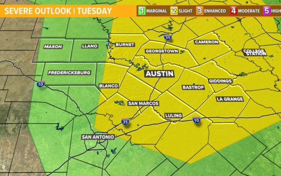
AUSTIN, Texas — The KVUE Weather Team is tracking the potential for another round of strong storms for Tuesday afternoon and evening in Central Texas. Here is a breakdown of the timing and threats for Tuesday’s storm chances.
Threats
The Coastal Plains and I-35 corridor is under a “slight” – 2 out of 5 – risk for severe weather according to the Storm Prediction Center, with the remainder of the region being in the “marginal” – 1 out of 5 – risk.
As for the main threats, we’re once again looking at large hail, with damaging winds being a secondary threat. Isolated tornadoes will also be possible with this system.
Timing
For Tuesday, we expect to start off with maybe one to two isolated showers for the morning, before a dry lull leading into the early afternoon.
It’s on Tuesday afternoon when we’ll watch for the better chance for scattered storms generally east of Interstate 35, which could involve some discreet cells that produce large hail.
Afterward, we expect this system to clear out as the instability drops throughout the overnight hours. However, we are also watching Wednesday night into Thursday, but we are too far out to give specific timing or the strength of those storms.
Stick with KVUE for the latest on this developing forecast.
In the meantime, your seven-day forecast is below.