- Western NC wildfire risk will 'get worse, not better' Ag Commissioner says, pressing lawmakers for help
- Watering trees is a must to protect them from severe weather and drought
- At least 4 dead, hundreds rescued after deadly floods ravage South Texas
- Today on Texas Standard: Deadly floods swamp South Texas, shatter records
- North Carolina radio station was a critical lifeline after Hurricane Helene. Then it became the voice of recovery.
Strong storms could produce severe weather across Carolinas Tuesday: Larry Sprinkle

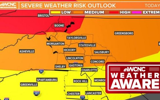
The biggest threat for severe weather will be in the mountains and foothills, while Charlotte’s biggest risk will be damaging winds and potential dime-sized hail.
CHARLOTTE, N.C. — Tuesday is a day to be Weather Aware in the Carolinas as there is a threat for severe thunderstorms in the Charlotte area in the afternoon and evening.
The mountains and foothills will have the highest risk of severe weather such as damaging winds, hail, heavy rain and isolated tornadoes, forecaster Larry Sprinkle said. The atmosphere will be ripe for severe storms with plenty of “thunderstorm fuel” in the mountains and foothills, Sprinkle explained. The potential energy will be elevated in areas such as Hickory, Lenoir and Morganton.
Those storms will move into the Charlotte metro by the late afternoon and evening with a second wave to come Tuesday night.
“It’s really this afternoon into the evening,” Sprinkle said. “Be Weather Aware and be prepared.”
A band of showers moved across North Carolina Tuesday morning, bringing rain to Iredell County and areas along Interstate 77 north of Charlotte. These showers won’t produce any severe weather and will be out of the region by midday Tuesday.
Sprinkle said the severe weather threat really picks up by late Tuesday afternoon when the first line of storms moves into the Carolinas.
“Around 6 p.m. expect a line of storms from Gaston County into the Upstate of South Carolina,” Sprinkle said. “By 7 p.m. they’ll extend from Gastonia to Charlotte, up I-77 to Statesville and the Virginia border.”
Cities and towns in the path of this line include Belmont, Charlotte, Cherryville, Cornelius, Denver, Gastonia, Hickory, Huntersville, Kannapolis, Kings Mountain, Lenoir, Mooresville, Morganton, Shelby, Statesville and Troutman.
A second line of storms will present another threat of severe weather Tuesday night. This line will move into the mountains and foothills before tracking into the Charlotte metro around 10 p.m. The foothills could see golf ball-sized hail and winds over 65 mph.
Areas with the highest risk of severe weather Tuesday night will include Conover, Granite Falls, Hickory, Hudson, Lenoir, Lincolnton, Morganton, Newton, Taylorsville and Valdese.
And while Charlotte doesn’t have the most potential for severe weather, the possibility is still there for damaging gusts, heavy rain, hail and possible spin-up tornadoes across the metro area.
“Our main threat in this part of the world, in Charlotte, is strong winds,” Sprinkle said. “Heavy rain is possible and maybe even some dime-sized hail.”
Sprinkle said the severe weather potential should fizzle out by 2 a.m. Wednesday as the storms push east of Charlotte.