- Helene forced a North Carolina restaurant owner to leave his home. He just lost his 'Cabin of Hope' in recent wildfires
- Carolina wildfires grow, evacuation orders still in effect
- Helene forced a North Carolina restaurant owner to leave his home. He just lost his 'Cabin of Hope' in recent wildfires
- Severe weather likely in the Carolinas on Monday
- 3 dead, flash floods overwhelm South Texas, with some areas receiving more than 12 inches of rain
Flash flood warning issued due to heavy rains in Charlotte area
The Charlotte area could see up to 7 inches of rain this week with even higher totals in the North Carolina mountains, chief meteorologist Brad Panovich said.
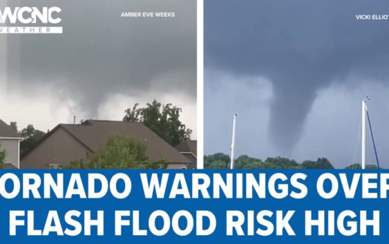
CHARLOTTE, N.C. — The Carolinas will need to be Weather Aware this week due to heavy rains leading to a significant threat of flash flooding with up to 8 inches of rain possible in some parts of western North Carolina.
WCNC Charlotte forecaster Larry Sprinkle said the Charlotte metro could see anywhere from 3 to 6 inches of rain with higher totals likely in the mountains and foothills. All of this rain would be in addition to what the region got Monday night when a wave of storms moved through with heavy rain and tornado warnings.
“This is a lot of rain,” chief meteorologist Brad Panovich said. “And I will tell you right now that this will likely cause flash flooding. I almost think it’s a certainty that somewhere in our area is going to see flash flooding.”
A flood watch is in effect for most of the Charlotte area through Thursday due to the heavy rain that’s expected this week. Counties under the flood watch include Alexander, Ashe, Avery, Burke, Cabarrus, Caldwell, Gaston, Iredell, Lincoln, Mecklenburg, Rowan and Watauga.
More Videos
“The flash flood threat as you get from the foothills and mountains, areas like Boone and Hickory all the way down to Shelby and the Upstate of South Carolina, that is a high possibility of flooding today,” Sprinkle said. “That would basically be west of Interstate 77.”
Closer to Charlotte, Sprinkle said we can expect up to 6 inches of rain this week. There’s still a serious risk of flash flooding, especially in low-lying areas along creeks and streams.
Tornado warnings were in effect for multiple counties in the Charlotte area Monday night, with several WCNC Charlotte storm spotters seeing a funnel cloud over Lake Norman. Fortunately, no tornadoes were confirmed and there haven’t been any reports of storm damage across the area.
Heavy rain in the mountains
Futurecast data shows the front pushing into the Carolinas Tuesday with waves of rain. The highest totals are expected in the mountains and foothills. Panovich said the jet stream’s Southeast flow will interact with the mountains, essentially putting the brakes on those showers.
“It’s probably going to have showers just sit there and dump rain, rain, rain and more rain over the next couple of days,” Panovich said. “As we get into the heating of the day, we see pop-up showers and storms re-enhance themselves and you’ll see more widespread rain.”
Some areas have seen hours of steady rainfall since Monday, Sprinkle said. Parts of Alexander and Catawba counties, north of Hickory and Interstate 40 toward Taylorsville and Wilkesboro, have gotten copious amounts of rainfall with tropical downpours. Sprinkle said those areas could see flooding this week.
“Since last night we’ve seen 3.5 inches in Hickory, around 3 inches in Salisbury and over 2 inches in the Charlotte metro area and more is on the way,” Sprinkle said.
Excessive rainfall outlook
Panovich said the Carolinas are under what’s known as the excessive rainfall outlook, meaning we’re at risk for flash flooding. The entire Charlotte area will be at medium risk for flash flooding through Thursday before it goes down Friday.
How much will it rain? It depends on where you are, but the biggest totals are expected in the mountains, where some areas could see up to a foot of rain this week, Panovich said.
Your photos of severe weather across the greater Charlotte area
There will be some breaks in the rain, but Panovich wants to make it clear that we’re in for a wet, miserable week. Don’t let a few dry hours fool you into thinking we’re in the clear.
“This setup is pretty nasty for rainfall,” Panovich explained. “We could see just wave after wave of rain this week.”
If you have any outdoor plans this week, you should be Weather Aware, knowing there is a chance of flash flooding and strong storms.
“That is going to be a huge risk this week,” Panovich said. “And it could be one of those things where it builds over time. Plus the rain on Wednesday could really lead to some excessive rainfall that eventually could cause creeks or streams to rise real quickly.”
How long will the rain last?
Panovich says the rain will begin to break up by the end of the week. There are signs that maybe later this week it will start to shift out of the Carolinas, but Panovich said he’s still not sure if the weekend will be dry.
“Going into the weekend I’m still going to have rain in the forecast but the chances start to dwindle down a little bit,” Panovich said. “Today, tomorrow, Wednesday, Thursday and Friday will be pretty soggy.”
Panovich thinks the Charlotte area will finally get a break as the wind direction changes by the end of the week.
Wake Up Charlotte To Go is a daily news and weather podcast you can listen to so you can start your day with the team at Wake Up Charlotte.
SUBSCRIBE: Apple Podcasts || Spotify || Stitcher || TuneIn || Google Podcasts
All of WCNC Charlotte’s podcasts are free and available for both streaming and download. You can listen now on Android, iPhone, Amazon, and other internet-connected devices. Join us from North Carolina, South Carolina, or on the go anywhere.