- Western NC neighborhood still reeling from Hurricane Helene flood damage
- Ashe County Schools reopen after Hurricane Helene hit area over a month ago
- Ashe County Schools reopen Tuesday after Hurricane Helene hit area
- Carolina Hurricanes foundation donates $50,000 to rebuild Asheville hockey rink
- Stress, shelter, and safety: Hurricane Helene's effect on domestic violence victims in NC
Timeline: Severe weather could impact Triangle Monday; Damaging winds, isolated tornado possible
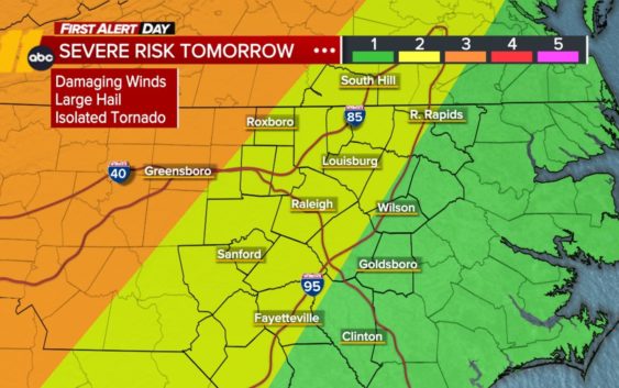
Along with the intense heat Monday, parts of central North Carolina could get severe weather setting up a First Alert Day.
Temperatures across the Triangle will be in the upper 90s but the heat index will push the feels-like temperature above 105 degrees.
In addition, the National Weather Service is to issue a Heat Advisory.
Stay weather aware and connected. Download the ABC11 App
Possible timeline of severe weather
First Alert Day: Level 2 severe weather risk on Monday. Storms across the Triangle area could pop off closer to dinnertime or sunset for the Triangle.
The main threats will be damaging winds and hail, but an isolated tornado is possible, especially near the Triad. The Triad area is at a level 3 risk.
SEE ALSO | Check all current weather advisories
Tornado watch vs warning: Here’s the difference and what they mean during severe weather
WATCH | Full ABC11 First Alert to Severe Weather Special
Quick tips to help you spot trees that are more likely to fall during severe weather