- A year after Texas’ largest wildfire, Panhandle residents tugged between hope and anxiety
- Another $500M for Hurricane Helene relief in North Carolina passes key hurdle
- Crews battle wildfire in McDowell County, NC
- Wildfire in McDowell County, NC is 20% contained, officials say
- California governor asks Congress for nearly $40 billion for Los Angeles wildfire relief
Rare level 3 severe weather risk, feels-like temperatures over 105: First Alert Day
RALEIGH, N.C. (WTVD) — It could be double trouble when it comes to weather in the Triangle.
There is a rare level 3 severe weather risk for later this afternoon that could be capable of bringing damaging wind gusts, hail and even an isolated tornado.
The highest risk for widespread severe storms to our west all the way to the Piedmont.
There is at least a 20% of storms starting at 6 p.m. The biggest chance for storms starts around 8 p.m.
Stay weather aware and connected. Download the ABC11 App
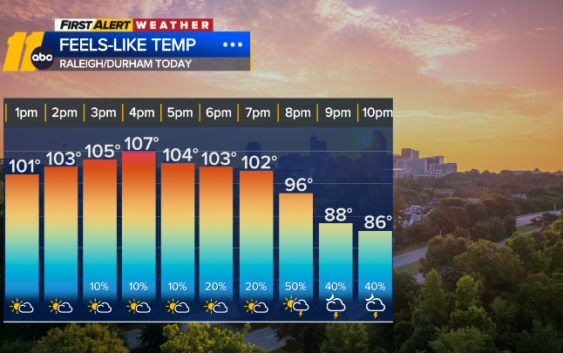
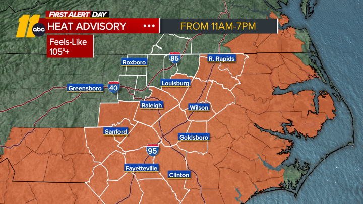
There is also a heat advisory in place from 11 a.m. to 7 p.m.
Dry and slightly more comfortable conditions look should move in overnight.
Check here for all weather advisories
The next chance for storms is on Thursday.
Tornado watch vs warning: Here’s the difference and what they mean during severe weather
Quick tips to help you spot trees that are more likely to fall during severe weather
WATCH | Full ABC11 First Alert to Severe Weather Special